Oregon's State Capitol city, often derided as a dull place, is actually, once you scratch the surface, a city with lots of interesting sights and activities. This walk will take you south of the State Capitol, through the Willamette University Campus, to the Historic Deepwood Estate and Bush's Pasture Park before returning through Salem's public hospital and the University campus to the Capitol building. There's lots of interesting architecture to look at along the route. The walk is 2.6 miles long, and has one significant hill n the neighborhood south of Bush's Pasture Park.

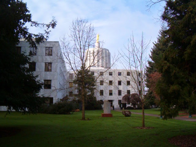
This walk starts at the beautiful Oregon State Capitol, constructed in 1938 after the previous capitol building burned to the ground in 1935. The part of the building in the foreground in this photo is actually one of two major 1977 additions, one on either side of the original building. This side is occupied by State Senators and their staffs. The entire building is scheduled to be vacated for over a year after the 2015 legislative session to accommodate a major seismic upgrade.
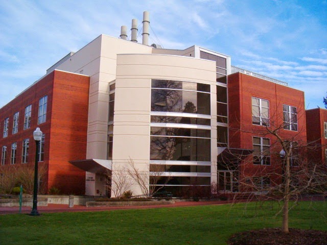
Start at the State Street side of the Capitol and turn left. Cross at the crosswalk near the intersection of State and Waverly to the Willamette University campus on the south side of State Street. The first building you will see is the newest major building on campus,
Ford Hall. Named for major contributor Hallie Ford (she also has the university art museum named for her), the building was completed in 2009 and houses several university liberal arts programs.
Walk to the right of the Ford Center, and then continue to the right of the next building, Smullin Hall, which houses Willamette's information technology functions. Once past Smullin Hall turn left, and to your right will be the Pelton Theater, guarded by two lions out front. The theater was completed in 1923.
Once past the Pelton Theater and the parking lot next to it, turn right. Continue to a bridge over Mill Race Stream. Immediately beyond is the Martha Springer Botanical Garden, opened in 1998 as a tribute to a long-time biology professor. The small one-acre garden includes 12 micro-gardens. Mill Race is a diversion from Mill Creek to Mission Creek that provided water power to the Thomas Kay Woolen Mill located upstream from this location as well as several other long-ago departed industrial enterprises.
After crossing Mill Race and looking at the botanical garden veer right and and then go straight ahead. On your right is the Mark Hatfield Library and on the left is the Sparks Athletic Center. Once you get to the parking area turn left along the sidewalk and pass by the front of the Sparks Center. Continue to the right along the side of a soccer field until you get to Bellevue Street.
Turn left onto Bellevue, and after one block use the crosswalk to turn right on 12th Street. As you proceed south you will see, in the distance to the left, Salem's Amtrak Station, a beautiful Beaux-Arts style building constructed in 1918. Continue along this busy, undistinguished section of 12th Street, to Mission Street. You will pass by the popular Ram pub as well as a bridge over "Mission Creek" (about which more will be said later on the walk).
After you cross Mission Street the scenery takes a turn for the better. To the right is the
Historic Deepwood Estate. This four-acre site is owned by the City of Salem as a public park, but the 1894 Queen Anne-style mansion is managed by Friends of Deepwood Estate, who provide organized tours of the home. The estate was given its name by Alice Powell, its final owner before the City acquired the property in 1971.
The estate is much more than just the grand mansion - the four acres of grounds also include beautiful gardens and a greenhouse that are open for free to the public. It is worth your time to wander through the gardens to admire the flora.

After you walk around and enjoy the Deepwood Estate grounds, go back onto 12th Street. After passing Lee Street, turn right onto Waller Street. After a block of ordinary apartment buildings you will come to this bridge, which crosses Pringle Creek. Use the bridge to cross the creek, then turn left onto the pathway.
You are now entering
Bush's Pasture Park, a 90-acre greenspace. A stroll through the western half of the park is included on
this walk - our route will go through the eastern part of the park. Continue past the trees into a large open grassy area, with trails that see a lot of use by joggers. Continue to the edge of the park at Leffelle Street, then turn right onto Leffelle (or stay on the pathway at the edge of the park which parallels Leffelle).
The neighborhood south of Bush's Pasture Park contains a number of old, attractive houses, such as this bungalow-style home, built in 1920, at the corner of Leffelle and Davidson.
Continue on Leffelle to its end at Summer Street, then turn left. Go one block and then turn right onto Cross Street. Go up a short hill on the next block, and at the top of the hill, after crossing Winter Street, is this stately Georgian-style home, built in 1934 for Custer Ross, a prominent local attorney. The American elm tree in front of the house is a lot older, dating from 1890, and is a
Salem Heritage Tree.
At Cottage Street turn right, and after one block you will reenter Bush's Pasture Park. Continue on the park trail that veers slightly to the left, on level terrain. When this path T's into another walking path turn right, and start going down a hill.
As you start on this path down the hill, to the right you will see this statue. It is entitled "Guidance of Youth," and depicts a pioneer family resolutely striding forward, presumably toward Oregon on the Oregon Trail. It was commissioned and placed on this spot in 1959 to commemorate the centennial of Oregon's admission as a state to the Union. Not mentioned on the plaque to the back of the statue is its interesting back story. It was commissioned and paid for with a $34,000 bequest from Carroll Moores, an evidently very thrifty janitor for the Oregon Supreme Court building. An earlier idea to use the money to purchase a painting of a nude by Auguste Renoir was the subject of significant local controversy, and was rejected.
After viewing the statue return to the trail and continue down the hill. You will be leaving the forested portion of the park and heading back into the grassy field portion of Bush's Pasture Park, but the last of the trees is this beautiful deciduous specimen.
At the bottom of the hill continue on the trail to the left. You will skirt the perimeter of the Willamette University baseball field and the University's McCulloch football stadium. The Willamette Bearcats participate in the NCAA at the Division III level. While the Bearcats don't have the consistent level of football excellence found at rival Northwest Conference foe Linfield College in McMinnville, the school plays at a generally high level, last winning the conference championship in 2008.

As you pass by the football stadium the trail branches. At the first branch go to the left, and almost immediately the trail will branch again - at this point, go to the right. You will be heading for the intersection of Mission Street and Winter Street. Cross Mission at the signal light, and proceed up Winter Street. You will soon be in going through the massive Salem Hospital campus. Salem Hospital is the only major public hospital in the city. Its recent plans to expand westward to Church Street has engendered
some local controversy.

At the north end of the Salem Hospital campus, between the hospital and Bellevue Street, you will pass over this waterway (earlier you passed over it while on 12th Street near the Ram Restaurant). It is shown on some maps as Mission Creek, but it is actually the
Shelton Ditch, a diversion canal from Mill Creek to Pringle Creek originally constructed in the mid-19th century. It is part of the complex set of creeks and ditches serving Salem with water that is for the most part diverted from the Santiam River to the south.

After Sheldon Ditch, you will cross busy Bellevue Street and continue north on Winter Street. You are now back at the edge of the Willamette University campus. On the left side of Winter, across from the main campus, is the Willamette University
College of Law. The college is one of three law schools in Oregon, and has a healthy rivalry with the University of Oregon and Lewis and Clark law schools. The law school's main building, the Truman Wesley Collins Legal Center, was built in 1967,
To the right on Winter Street, before its intersection with State Street, is the
Olin Science Center, constructed in 1995 and housing Willamette's biology and chemistry departments.

Continue on Winter Street until it tees into State Street. On the block to the left are a series of interesting buildings. On the corner is the Civic Justice Center, home of the
Oregon Law Commission, which inhabits Salem's
1912 Carnegie Library, with a classic beaux arts style used in many such libraries around the world. It served as Salem's public library until 1971, then was used by the YWCA until 2008, when it was refurbished by the law school and dedicated by none other than Supreme Court Justice Ruth Bader Ginsburg. Next on the block is the modern-style YWCA building, which has now been vacated by the YWCA, constructed in 1954. The architect was
Pietro Belluschi. Next down is the art-deco style
Pacific Telephone and Telegraph building, now occupied by CenturyLink, built in 1930. Finally, on the corner of State and Cottage, is the
Hallie Ford Museum of Art, opened by Willamette University in 1998, with an excellent collection.

After taking a look at these buildings, turn right on State Street and return to the State Capitol. You will pass by the other 1977 addition to the original capitol, which primarily is occupied by members of the State House of Representatives and their staffs.


 When you get to Hawthorne Blvd. take a left, but first glance to the right and you will see a block away the imposing Western Seminary mansion that you passed earlier along the route. Quickly turn right onto SW 53rd Avenue. At 53rd and Salmon, to the right, is this impressive 1911 home.
 Continue on 53rd Avenue. On the left, one house before the intersection of 53rd and Taylor, is this home built in a traditional early-20th-Century style. But it has that "new" look. Another tell-tale sign: if you look closely the house appears to have no basement windows, and therefore no basement. In fact, this house was constructed in 2010. It is much more respectful of neighborhood architectural traditions than the houses plopped into neighborhoods like this from the 1960's through the 1980's.