Sullivan's Gulch, a drainageway east of the Willamette, has played a
long illustrious part in Portland's city history. It is now a major transportation corridor running to the east, with an interstate freeway, a major freight railway, and, in part, Portland's east-west light rail line sharing the route. In the future a major
bicycle and pedestrian trail will be fitted in as well. This walk crosses over Sullivan's Gulch twice along its 3.7-mile flat route, and also goes through some great neighborhoods and the burgeoning Lloyd Center district. On the south side of the freeway the walk goes by Benson High School, Buckman Park, and a certain famous doughnut shop, which is where the route begins.
This walk starts at the legendary Voodoo Doughnuts shop. Except that we are not at 3rd and SW Ankeny in downtown Portland - we are at
Voodoo Doughnut Too, located at 1501 NE Davis on the east side of the river. As you can see by the bright purple line dividers, this Voodoo outlet can get pretty crowded too, but it is generally a much shorter line, and the doughnuts are the same. You don't lose much in atmosphere here either!
From the entrance of Voodoo Doughnuts go west on Davis Street to 15th Avenue. Turn right and when the street ends walk up to Buckman Field Park. This well-used recreation area doubles as the athletic facilities for adjacent Benson High School. Turn left at the track and walk around the circumference of the soccer field.
After traversing a large portion of the track you will come to this building, which is the Buckman Recreation Center. The building looks pretty old, but I cannot find any information about its age or history.
After passing the Recreation Center building go straight where the track curves to the right. The building straight ahead is Benson Polytechnic High School. Turn left onto the driveway adjacent to the building and walk to 12th Avenue, then turn right. The front facade of Benson High is along 12th Avenue. Benson High has been in this location since 1917. It is named for Simon Benson, early Portland civic leader (of Benson Bubbler fame), who donated half of the Portland School District's $200,000 cost to build the school. The school's
Wikipedia page provides a pretty good summary of its place in the Portland School District.
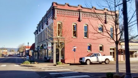
Continue on 12th Avenue across Hoyt Street, but first make sure to cross to the west side of 12th Avenue before proceeding any farther north. The building on the right houses Point West Credit Union, but it has an interesting history. It was constructed in 1932 as the club house for the 9-hole
Lloyd Golf Course, which spread behind it and down into Sullivan's Gulch to the north. By 1955 the golf course was closed and replaced by the Banfield Expressway (now the I-84 freeway), but this building remained and was "recycled" as a financial institution.
12th Avenue crosses Sullivan's Gulch on a bridge. Below you is the noisy freeway and the Union Pacific freight line. The MAX light rail line doesn't go into the Gulch until 16th Street farther to the east. It is unclear where the proposed bicycle and pedestrian trail will fit in. There are signs of significant homeless and transient usage of Sullivan's Gulch - such usage has some
interesting history.
Once across the freeway and rails take a left at Lloyd Avenue. Cross to the right at 9th Street and then immediately turn left onto Oregon Street. The building on your left is the Oregon State Office building for Portland, with its distinctive roof design.
When you reach the entrance to the State Office Building cross Oregon Street to the right and head up this pedestrian pathway for two blocks to Holladay Street. The gazebos to the right host the
Lloyd Farmer's Market every Tuesday throughout the year.
The buildings on either side of the pathway are a low-rise office development known as Oregon Square. They are scheduled to be replaced by a
massive new apartment project with over 1,000 units in 4 high rise towers, and in the middle a
large open space plaza, which may or may not continue to host the farmer's market. It would be the largest of the many apartment projects that have been built in Portland since 2012 or so.
Upon reaching Holladay Street straight ahead you will see a new apartment complex that, until Oregon Square is redeveloped, is the largest such new development in Portland in many years.
Hassalo on Eighth consists of three buildings with 657 apartment units, retail on the ground floor, and space for 1.200 vehicles in its underground parking garage. The buildings are under construction and almost finished at the time of the posting of this walk.
Turn right onto Holladay Street, named for one of Oregon's
robber barons. The street is the location of rails for the Portland MAX light rail network. Three lines run along these tracks, which will merge a few blocks to the east into Sullivan's Gulch on their routes to the Portland Airport, Gresham, and Clackamas Town Center.
Continue along Holladay Street to 11th Avenue, where you will come to Holladay Park on the left. Enter the park and walk diagonally across it to the corner of 12th Avenue and Multnomah Street, across from the Lloyd Shopping Center.
The Lloyd Center, on the north side of Multnomah Street, is Oregon's first indoor shopping mall, opening in 1960. For now it remains viable, but its fate in the days of disappearing shopping malls will be interesting to follow in coming years.
Continue on Multnomah Street to 16th Avenue, then turn left. Two high rise residential buildings are located near this intersection. The complex on the left is
Holladay Park Plaza, a large retirement community with options from independent living to skilled nursing care. The high rise on the right is the Fontaine, built in 1963, now converted into condominiums.
Follow 16th Avenue north and as is starts to curve to the left you will see a walkway continuing straight ahead. Take the walkway and follow it to the right around the side of the Holladay Park Plaza high rise. Continue straight ahead onto Clackamas Street. After crossing 17th Avenue the neighborhood abruptly changes from the Lloyd District to a street of early 20th century homes mixed with two-story apartment buildings constructed in the 1960's and 1970's. The older homes are much nicer to look at.
This house, at the corner of Clackamas and 19th Avenue, was constructed in 1906. It is a great example of the "four-square" or "farm-house" style popular at the time. A full attic and full basement, when improved, add considerable square footage to this style of home.
Continue on Clackamas Street, carefully crossing busy 21st Avenue. One block further, at the corner of Clackamas and 22nd, is this 1907 home built in the
Craftsman style.
Cross 22nd Avenue. After an apartment building on the right you will see this home, built in 1918. It is strikingly different from the colonial and craftsman bungalow styles more prevalent in the early 20th century, looking much more modern. It exemplifies the
Prairie style of architecture, a school of design inspired by America's most famous architect, Frank Lloyd Wright. A second example of the Prairie style will be found later on the walk route on Multnomah Street.
Continuing along Clackamas, after a few more houses you will see this great example of another popular architectural style of the early 20th century, the Dutch colonial, with its distinctive gambrel roof. This home, on the left side of the street, was built in 1923.
At 24th Avenue turn left, and then cross over to the right side of 24th. After crossing Halsey Street you will see two older attractive apartment buildings, both built in the 1920's. The first is this one, which can be described as a Spanish-Craftsman mixture, and the second is a brick building. To me the most notable aspect of these two apartment buildings is that neither appears to provide any off-street parking for residents. With all the fuss over new no-parking apartments in Portland the past few years, it is interesting to note that it's not a new phenomenon.
Continue on 24th Avenue past Weidler, which is where the busy Broadway-Weidler couplet system of one-way streets ends and combines onto NE Broadway going east. On the corner of Weidler and 24th is another attractive old apartment building without any off-street parking. And on the corner of Broadway and 24th is this grand old 1909 church, now home to a very modern congregation. The
Metropolitan Community Church, part of a worldwide organization of 222 churches, came to this location in 1977 to minister to Portland's gay community, at a time when homosexuality was an unwelcome subject and homosexuals were generally pariahs not only at conservative "fundamentalist" churches, but also among mainstream Protestant denominations. Those times have changed (at least among the mainstream Protestants), but the Metropolitan Community Church is still church devoted to ministering to the needs of a predominately gay congregation.
Cross Broadway at 24th Avenue (at the signal light) and then turn right on Broadway. The next several blocks contain the usual mix of storefronts for this type of neighborhood. One of the most notable is an outlet of Arthur Murray Dance Studio. There are enough of these studios around town to indicate that a market for ballroom dancing lessons still exists! Also along this stretch of Broadway, on the left side, is
Coco's Donuts, definitely without the Voodoo ambience, but with doughnuts as good or better according to its fans.
At 28th Avenue turn left, and after one block turn right on Schuyler Street. The next two blocks contain a nice mixture of Portland homes, including this one. While built to the pre-existing neighborhood style, the under-house garage and lack of any other basement betray the fact that it is a newly-built home in this old neighborhood.
Continue on Schuyler for two blocks to 32nd Avenue, then turn right. Cross Broadway at the signal light. Ahead is
Grant Park Village, a large redevelopment project on the site of an old sloping industrial development adjacent to the I-84 freeway. The building contains 211 apartments and a New Seasons market. It opened in late 2014. It is another interesting example of the "densification" of the central neighborhoods in Portland.

Continue on 32nd Avenue one short block to Weidler Street, then turn right. On your left is the market New Seasons is challenging in this neighborhood, the Fred Meyer Hollywood West store. This Fred Meyer was completed in the mid-1980's, relocating from one of the original Fred Meyer stores across from the Hollywood Theater 13 or so blocks to the east on Broadway. The contrast between this 1980's store and the New Seasons Grant Park Village development is striking. Now completely forgotten, the construction of this Fred Meyer was hugely controversial in the 1980's - this store also replaced an industrial use located along Sullivan Gulch and the Union Pacific railway Now the only obscure reference to the controversy that can be found online is
this page, in the annals of the Oregon Land Use Board of Appeals. A click on the first of the 1987 opinions, Younger v. City of Portland, will take you to a high-powered battle between opponents, who hired noted Oregon land use attorney Ed Sullivan, Fred Meyer, and the City of Portland. As you can see with your own eyes, Fred Meyer prevailed, with the case eventually being resolved by the Oregon Supreme Court.

Follow the frontage of Fred Meyer along Weidler Street, then turn left onto 28th Avenue. Note that all of the streets entering onto 28th from the Sullivan's Gulch residential neighborhood to the right have been blocked to vehicular traffic - one of the mitigation measures installed in the 1980's to prevent Fred Meyer traffic from entering from or exiting into those neighborhoods. After following the curve of 28th, turn right onto Wasco Street (it is the last street before 28th crosses the I-84 freeway and the MAX line to the south). Once again the neighborhood is a mixture of attractive early 20th century houses with a few 1960s-1970s apartments in the mix. This 1905 "farmhouse" style home is located at the corner of Wasco and 26th.

Continue on Wasco to 24th Avenue, then turn left. After one block turn right onto Multnomah Street. On the left, with the freeway and MAX line behind it, is this bungalow court done up in a mock English Tudor style. Note, once again, the absence of off-street parking. On the right side of Multnomah is another striking example of the Prairie residential style inspired by Frank Lloyd Wright.
At 21st Avenue turn left and use the bridge to cross Sullivan's Gulch again. At this point the 84 freeway and Union Pacific tracks have been joined by Portland's MAX train line, as it leaves city streets and picks up speed on its routes to the airport, Gresham, and Clackamas.
After crossing Sullivan's Gulch 21st Avenue splits in two - take the road to the right, which becomes 20th Avenue. The building at the "V" intersection with its antenna is the dispatch center for Portland's fire alarm telegraph system, The system was lauded in a paper written by the Works Progress Administration during the 1930's as a model for the rest of the nation. Behind the antenna is the Sunshine Dairy building, a non-descript industrial facility highlighted with a milk carton sign above it.
Continue on 20th Avenue to Irving Street, then turn right. On the left, between 18th and 16th Avenues is the Parkview Apartments. This complex of two-story buildings was completed in 1941. It is on the National Register of Historic Places. Proceed into the complex at the pedestrian entrance between 18th and 16th Avenues to best appreciate the design and park-like setting. After the first set of buildings turn right and return to the street grid on 16th Avenue.
Once on 16th Avenue turn left. Go to Sandy Blvd., where you will turn right and then quickly right again onto Davis Street. Ahead will be your starting point, Voodoo Doughnuts.


 ,
,