COUNCIL CREST FROM DUNIWAY PARK - SW PORTLAND
This walk will give you quite a workout - climbing from Duniway Park (elevation 154 feet) to Council Crest, one of the highest spots in Portland (elevation 1073 feet), with sensational views from the top. The route up mostly goes through the beautiful Marquam Nature Park, while the trip down goes through some great neighborhoods in the Portland Hills, and finishes with an amazing stairway. The entire route is 4.3 miles.
This walk starts at Duniway Park, named for Abigail Scott Duniway (1834-1915), a famous Oregon pioneer who walked the Oregon Trail at age 9, and then went on to a career as a womens' rights advocate and newspaper editor. Use the restrooms, located on the east side of the park near Barbur Blvd., because there are no public restrooms at the top of Council Crest or anywhere else along this walk.
Parking might be tricky if you are driving to Duniway Park. There are a few places in a parking lot that can be entered from Barbur Blvd, but they are only one-hour spots. On-street parking on Barbur Blvd. is marked for two-hour maximum, and you should be able to finish the walk in that amount of time if you don't stop to "smell the roses." And finally there are other on-street spots nearby that are marked 90-minute maximum, but only Monday through Friday (to keep OHSU and downtown commuters from monopolizing all the spots). They have no time limits on weekends.

The park has a track around a grass field that often has soccer games and other athletic events going on. Cross the track and head up the hill until you reach the sidewalk along Terwilliger Parkway. Directly in front of you is Terwilliger Plaza, a large multi-story retirement complex. At the top of the park you will start up Terwilliger Parkway, a beautiful greenway that continues for several miles through southwest Portland. Through the tops of the trees on the hill to your left are glimpses of the Oregon Health and Sciences University (OHSU) campus - "Pill Hill" to Portlanders.

Continue up the parkway, but when it makes a hairpin turn to the left you will continue straight, ending up on Sam Jackson Park Road. This leads to the main entrance of OHSU. After a few hundred feet the sidewalk ends, and you will need to watch for passing traffic navigating the next few hundred feet to the Marquam Nature Park entrance. I would suggest using the wide shoulder on the left to start, and then carefully crossing the street and using the wide shoulder in front of the water tank on the right. The last 100 or so feet will be on a narrow shoulder, and then you will be safely in the Marquam Nature Park trailhead area.
The next mile goes uphill through a quiet forested area, with only city background noise to remind you that you are in the midst of Oregon's largest metropolitan area. Most of this portion of the hike hugs the side of a forested ravine. There are several trail forks and trail names, but you won't go wrong if you just follow the directions for Council Crest and stay on the 4-T Trail.
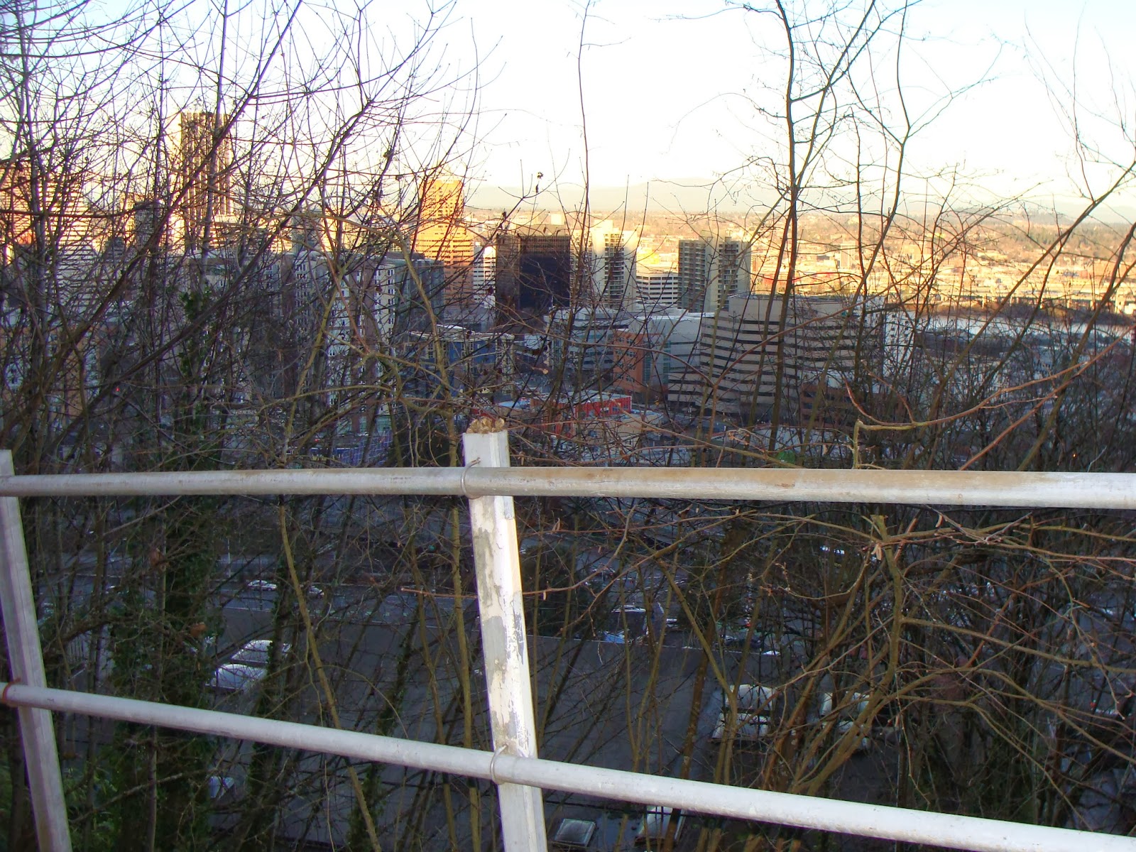
At the top of the drainage you will hit six switchbacks in a row. Soon after you will once again see signs of civilization - houses on the cliffs above you. The stairs shown in the picture lead to Sherwood Drive. Cross this street and continue on the trail up the hill.

You will now be passing below houses that front on Fairmount Drive, which you will soon be crossing on your way to the top of Council Crest. This house in particular makes a striking architectural statement from the rear. Soon you will come to Fairmount - cross this street and continue up the hill on the trail, paralleling the street. Do not be tempted to walk on Fairmount instead of the trail. Although Fairmount circles Council Crest on a fairly level but winding, route and is popular with walkers and cyclists, it has no sidewalks or separated walkways and often has narrow shoulders. There's no reason for you to walk on it when off-street trails are available as an alternative. Next, you will come to Greenway Avenue, which the trail also crosses on your way to the top. Greenway Avenue is the location of a former Portland Streetcar line which made its way to the top of Council Crest until the 1940's.

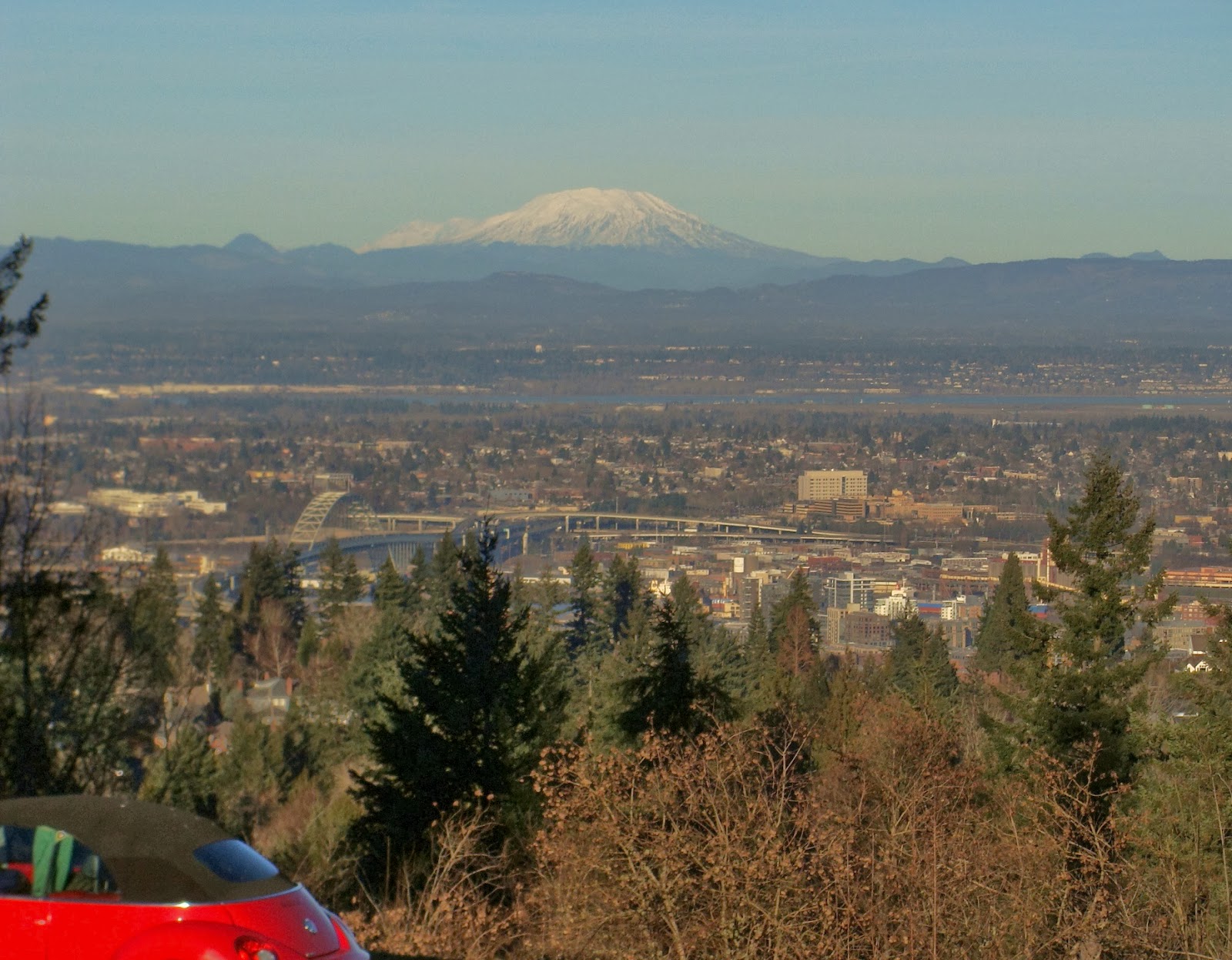
Keep on trucking up the last few switchbacks, and soon you will arrive at the top. On a clear day, these are the views you will see of Mt. Hood and Mt. St. Helens. There are nice grassy area and benches at the top for you to relax and enjoy the scenery. It is hard to believe, but from 1907 to 1929 Council Crest was the site of an elaborate amusement park.
The full history of the amusement park, along with fascinating old pictures, can be found at
this site.
When it's time to head down the hill, start down the trail you came up on, but within 100 feet you will see this junction - you came up the trail on the right, but you will head down the trail on the left, which is also signed as the Wildwood Trail. If you are so inclined, you can follow this trail all the way across Washington Park and the Portland Zoo, to Pittock Mansion, and on to the nether regions of Forest Park many miles to the north.
But you won't be going that far on this walk - the second half of the walk, which takes you the rest of the way down the hill and back to Duniway Park, goes through residential neighborhoods. The trail comes to an intersection where Talbot Road, Fairmount Road, and Talbot Terrace meet. Be careful to avoid the first possible right turn, which is Talbot Terrace. Take the next right turn beyond, which is Talbot Road.
Talbot Road has no sidewalks, but there is a shoulder on one side of the road or the other and not a lot of traffic. Before you get to the Greenway Road bridge shown in the picture, you will see a stairway down the hill to the left. Take it, and you will land on Montgomery Road. This street is also without a sidewalk for a few hundred feet, but there is no significant traffic since it is a dead-end road. And a sidewalk begins soon enough. Enjoy looking at the nice homes on both sides of the street - and this is one of the more modest Portland West Hills neighborhoods!

Montgomery eventually meets up with Patton Road. Turn right, and continue as Patton turns into Broadway. But soon Broadway veers right and starts down the hill. You will be taking a less traveled route to the left, a slight uphill on Ravensview Drive. Follow Ravensview as it curves up the hill. At Terrace Drive continue straight; this street becomes Hawthorne Terrace. Enjoy viewing the fine residences on both sides of these streets, many with panoramic views of the mountains above and Portland below.
Hawthorne Terrace ends at 16th Avenue - make a slight right onto 16th, and then turn left onto SW Davenport Street. Davenport does not have a street sign in this location. Continue down Davenport, and you will pass a wooded area which a map of Portland labels "Governor's Park" but has no sign indicating that it is anything but a large, wooded, steeply-sloped, vacant lot. There is an interesting history behind this particular Portland park, documented very well at
this site. The "Governor" who donated this park site was Governor Sylvester Pennoyer, also for a time Mayor of Portland, a populist and somewhat disreputable late 19th century Oregon politician. He made a name for himself with anti-Chinese nativist populism that curdles the blood when read today. Lawyers and law students should know that he is the "Pennoyer" of
Pennoyer v. Neff, a late 19th century Supreme Court decision that is studied in every law school first-year Civil Procedure class.

Once you pass Governor's Park, Davenport trends down the hill. You'll go through some very nice neighborhoods and see sweeping vistas of Portland and the Cascades to the east. When Davenport ends you will begin a series of road switchbacks down the hill. While there are no sidewalks here, traffic is light and slow - just keep yours eyes open for cars. Davenport turns into Chelmsford - when this street ends make a left onto Buckingham, then a right onto Cross, then a left onto Commonwealth, then a slight left onto Sheffield, and finally a right onto Hoffman.
At this point, you will be in front of what looks like a 2-3 story condominium complex. You are right above downtown Portland, about at the level of the taller skyscrapers. Continue down Hoffman past the condominium complex on your left until you see the start of what is about the craziest and steepest stairway in the city. This stairway takes you straight down the hill, at such a steep angle that the stairway itself has to make switchback turns! As you go down, you will see that the 2-3 story condominium complex is actually about five stories tall, with a whole set of condos below the grade of the street.

When you get to the bottom, you are on Broadway. Broadway has no sidewalks, so carefully cross the street and start down a narrow walkway which will become a street, Sherman Street, that take you to Sixth Avenue. But before you go, look back and view the stairway you just went down, and think about residents of those condos trudging home from downtown up those stairs after a long day at work!
Continue on Sherman, and then turn right onto Sixth Street. Walk up the street, past the Terwilliger Plaza retirement complex, and you will be at the upper end of Duniway Park. Retrace your route down the trail, across the running track and athletic field, back to your starting point. Congratulations, you've just finished over 4 miles of walking, and survived almost 1000 feet of elevation gain!


 Continue on Court Street across busy 17th Street - the street ends at 18th Street. But this pedestrian bridge on the left side of the street will allow you to cross Mill Creek, and continue on Court Street to 20th Street, where you turn left. Continue on 20th Street past McRae Park, and turn right on Breyman Street. Follow the street to its end on 24th Street, cross the street, head left for a couple hundred feet, and enter the Oregon State Hospital grounds to the right.


