South Salem is the nicer part of town - the topography goes up a bit and residents in the early 20th century tended to put nicer houses up on the heights. This walk starts near downtown and goes to Mahonia Hall, the official residence of Oregon's Governors, and back. The walk is 3.5 miles, with moderate ups and downs.

The walk starts at the Pringle Park parking structure on SE High Street and Mill Street. Parking is $5 per day from 8 AM to 6 PM on weekdays and free at other times.
From the parking structure proceed south on High Street. You will cross Pringle Creek, one the many Salem creeks that used to provide water power for mills in the 19th century. On the other side of the creek is the edge of Salem's largest historic district, the Gaiety Hill-Bush's Pasture Park area. Almost immediately on the right, at the corner of High and Oak Streets, is the Jarman House, a beautiful 1929 Spanish Revival home. There are several other large historic homes in this two-block stretch of High Street.
At Leslie Street turn right and go one block to Liberty Street. At Liberty turn left, but before doing so look at the northwest corner of this intersection, Salem's civic center, including the city hall and library, was constructed here in 1972. The architectural style of these concrete buildings is appropriately known as "brutalist," representing in many minds the worst of "modern" post-World War II architecture.
After turning left on Liberty Street proceed one block to Mission Street, and then cross Liberty at the signalized intersection, heading right on Mission. Go one block on Mission to Commercial Street. At Commercial turn left. On the right side of the street is
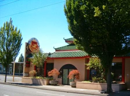
Kwan's Chinese Restaurant, in this location since 1982, and generally thought to be the best Chinese restaurant in Salem.
After one block on Commercial turn left onto Kearney Street, but before doing so note
Gerry Frank's Konditorei on the southwest corner of this intersection. This bakery, located here since 1982, is acknowledged as the best dessert spot in Salem. Gerry Frank is a scion of the Meier and Frank department store family, for many years chief of staff to Governor and then Senator Mark Hatfield, and is an Oregon institution. He also has a Sunday Oregonian column with restaurant and lodging recommendations around the state.
After a block's walk on Kearney turn left onto Saginaw Street. After two blocks you will cross busy Owens Street, which is a main route toward the Willamette River south of Salem. Continue south on Saginaw Street. After four blocks, at the corner of Saginaw and Leffelle, is the office of the Salem
Family Literacy Center. This program, administered by the Salem-Keizer School District, aims to help young parents attain a GED and other education needed in today's workplace, while also providing pre-school and other family services.
After one more block on Saginaw turn right onto Lincoln Street and head up the hill. You are now in the Fairmount Historic District, which encompasses several blocks west of Commercial Street. Lincoln Street is lined with fine old homes. One of the most notable is the Otto Johnson House (325 Lincoln Street), a colonial mansion on the right side of the street. Built in 1930, its original owner was a local JC Penney executive. Today it serves as the Willamette University President's quarters.

After three blocks Lincoln Street ends, so turn left onto John Street. However, at the corner of Lincoln and John is Mahonia Hall, official residence of Oregon's Governor. The Tudor-style mansion was originally built in 1924 for Thomas Livesley, a wealthy hops farmer. It was purchased in 1988 with private donations as the Governor's residence. After a period where the mansion was sparingly used by former Governor Kitzhaber, it is apparently once again the actual residence of Governor Kate Brown. The mansion is securely gated, so you will have to peer at it through iron bars.
After one block on John Street turn right onto Washington Street. The road dead-ends, but a path continues down hill one block to Riovista Way. While trees get in the way, there is a view of the Willamette Valley below, with its rolling hills and fertile crop land.
On Riovista Way turn left and go one block. There you will see this stairway heading back up the hill to the left. Take it, and you will end up on the upper end of Superior Street. Continue straight ahead back down the hill.
Not all of the homes in the Fairmount Historic District are mansions, but even the smaller ones are a pleasure to look at. A fine example is this colonial style house at the northeast corner of Superior and John Streets, built about 1925. The comfortable lawn chairs speak to lazy, pleasant summer days and evenings.
Continue down Superior Street to Saginaw Street, then turn right and go two blocks to the no-longer- correctly-named Rural Avenue. At Rural turn left and go one block to Commercial, crossing this busy street at the signal light. After crossing continue two blocks on Rural to East Nob Hill Road. Turn left here and go two blocks north. There are two streets in this pre-World War II subdivision, East Nob Hill and West Nob Hill. The subdivision has typical smaller homes in popular architectural styles of that era.

At Superior Street turn right and go one block east to High Street, where you will turn left. After a very short distance on High Street, turn right onto Howard Street and go one block to Church Street. On the corner of Church and Howard is South Salem High School. This school was opened in 1954 as Salem's second public high school. Since the original Salem High School (now North Salem High) are nicknamed the Vikings, South Salem became the Saxons. The city now has six public high schools.
Turn left onto Church Street and walk north for three blocks. Most of the homes in this neighborhood are also pre-World War II, with a couple of jarring exceptions built later in more modern styles. After three blocks Church Street ends at Bush's Pasture Park. Continue straight ahead into the park and proceed north on the walking trail. The 90-acre park is named for Asahel Bush, founder of Salem's Oregon Statesman newspaper and original owner of a house on the current park grounds.
The park trail walks through tree areas and grassy pastures. To the right, down the hill, you will get a view of McCullough Stadium, home to the Willamette University Bearcats football team. Next to the football stadium is Spec Keene Stadium, Willamette's baseball field.
Continuing north on the park path will bring you to the Bush Barn Art Center, located in a historic barn next to Asahel Bush's former home. The Art Center is operated by the Salem Art Association and has five arts and crafts galleries. Admission is free. Next to the barn is this playground noted for its crooked house play structure.
Beyond the playground is the Asahel Bush house, constructed in 1877. The house is also operated by the Salem Art Association and features period furnishings. It is open for guided tours.
Turn left in front of the Bush house and head west, between the house and the Bush Barn. Behind these structures is a beautiful municipal rose garden, with this gazebo as its centerpiece. It is maintained by
Friends of Bush Gardens, a nonprofit organization.
Continuing west, before you reach High Street take the trail to the right that goes around and below the rose garden. The trail will take you to the intersection of Mission Street and Church Street where you will cross Mission Street and head north. Church Street contains several historic homes on its left side. Cross Pringle Creek and then take a left onto a creekside trail on the north side of the creek. Follow the trail through a tunnel under High Street, and you will return to your starting point at the Pringle Park parking structure.