The City of Sandy has fewer than 10,000 residents, and is known to most only as a small city through which Highway 26 goes through on the way to Mt. Hood and points east. And, truth be told, while Sandy looks like a nice place to live for its residents, there is not a lot to see here. But there are a few things in the "downtown" area that are worth a walk. And this short 1.2 mile trek, with a bit of up and down terrain, would provide a nice little stop for someone wanting to see something new on the way elsewhere to more familiar sights.
The walk starts at the main parking lot of Meinig Memorial Park, established on this site in 1963. To get to the parking lot turn right from Highway 26 (Pioneer Blvd.) onto Highway 211, and then left onto Meinig Road. The parking lot is a few hundred feet down the road on the left.
From the parking lot start walking east, away from Meinig Road, along a forested pathway. The park has some nice covered picnic shelters and this wooden bandstand, where small concerts take place occasionally.
The trail has both left and right turns, but continue straight until you reach the east end of the park at McCormick Drive. Continue onto the street and go one block to Wolf Drive, where you will turn left and go one block to State Route 26, the Mt. Hood Highway. You will reach the roadway at a point where a one-way couplet system of Pioneer Blvd. and Proctor Blvd. ends and turns back into a two-way highway headed eastward to Mt. Hood. Turn left onto Pioneer Blvd. and head back west.
The road has a nice sidewalk, but also a lot of traffic. While the one-way couplet system certainly speeds traffic through Sandy, it has had a negative impact upon the city's downtown cohesiveness - as is usually the case with such one-way couplets installed to speed the flow of traffic. Soon on the left is the Sandy City Hall, a nice northwest contemporary structure with this interesting mural in the front.
Soon after Sandy City Hall, also on the left, is Joe's Doughnut Shop, a well-known stop for skiiers with a sweet tooth before or after their day on the Mt. Hood slopes.
Continue down Pioneer Blvd. The block on the north (right) side of the street contained many of Sandy's original structures. However, since they were built with wood, they all burned down by the mid-20th century and were replaced with the more modern structures in place now. But on the south (left) side of the street older structures remain. At the corner of Pioneer and Junker Street is the Caspar Junker home, constructed in 1908. This modest residence was built by Mr. Junker, a noted local businessman and mayor.
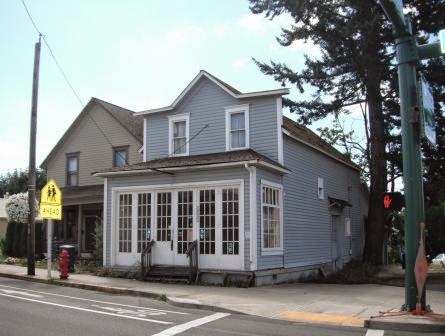
Continuing another block on Pioneer Blvd. at the intersection with Strauss Avenue, to the right, is the Sandy Meat Market building built in 1909. The store was constructed and operated by the Hoffman family.
After another block on Pioneer Blvd. you will arrive at the Evangelical Lutheran Church building on the right, constructed in 1902. The Lutherans moved on in the 1950's to a new building, and an Episcopal congregation moved in for a while. Today the building is used for non-sectarian purposes. Next to the church, to the west, is the old parsonage house, constructed soon after the church, which now holds Otto's Cross-Country Ski Shop.
Beyond Otto's Ski Shop, also on the right side of Pioneer Blvd., is the Lutheran School building, constructed in 1904. Its days as a schoolhouse are long past, and today it is the site of Schoolhouse Natural Medicine.
Between Otto's Ski Shop and Schoolhouse Natural Medicine is a stairway to the rear of these buildings. Go down the stairs and follow the rear sidewalk to the left that runs between the buildings and a parking area. At the end of the parking area turn right onto a driveway heading down the hill. Where the driveway ends a trail continues down the hill. Take the trail, and head into a residential area.
At the bottom end of the trail is Tupper Road. Turn left and head back east. After a few hundred feet you will reach the intersection of Tupper and Highway 211, which connects Sandy to Estacada. Cross the two-lane highway and then turn right and head down the hill on a trail that parallels the street. You are now back to Meinig Park - continue along the trail to the parking lot where you started the walk.