Sunday, September 13, 2015

Hood River


Hood River is a small city in a spectacular setting - the heart of the Columbia River Gorge. The hillside setting provides great views of the river and gorge, which you will see a lot of from the route of this 2.2-mile walk as it traverses up and down the city's hillside (including a 413-riser stairway!). A car trip up the Hood River Valley will take you through some of the nation's best apple and pear orchards, and eventually to Mt. Hood itself. The gorge and mountain are location to many spectacular nature walks, so this city walk might be a nice change of pace for frequent visitors or vacationers.


Our walk begins at this waterfall on State Street, at the south end of 2nd Street (at least the south end of the vehicular travel way!). Take a look up the steep hill - you will become very familiar with it in the near future!


Head up the first flight of steps next to the Big Horse building. On your right is Stratton Gardens, opened in 2002, which transformed a 6,000 square foot lot into a pretty little public garden.


Continue up the hill. If you aren't already tired, you soon will be, but the climb will be worth it. The Second Street Stairs, also known as Gil's Stairs (named for long-time City Councilor Gil Jubitz), have 413 steps, making them one of the longest public stairways in the United States. I suppose one could argue that, since the stairway is intersected by five streets, it isn't really a continuous stairway. But consider the intervening streets to be landings, allowing you to rest before continuing up, and up, and up. While the current stairs were constructed in the 1940's, earlier versions date from the early 20th century. If you need to take a break, turn around and enjoy the panoramic views of the Columbia River.

Eventually you will reach the top of the stairs at Montello Avenue. To your left is this beautiful old hilltop home, built in 1900 with spacious grounds overlooking the city.


Turn right on Montello Avenue and proceed west, enjoying the views to the right of the city and the river. There are many old, attractive residences along this street. At the corner of 9th and Montello is the historic Simpson-Copple house, built in 1906 in the vernacular late Queen Anne architectural style. It is on the National Register of Historic Places.


At 9th Avenue turn right and use the stairway to start back down the hill (it's a lot shorter than the 2nd Street stairs). The narrow green space along the downhill side of Montello Avenue is actually a city park. Gracing the stair landing is this little statue of a batter. Continue to the end of the stairway on Eugene Street and then turn left. On your right is the Hood River Children's Park, with an attractive play area.


At 9th Street make a slight dogleg to the right and then continue to the left on Eugene Street. On the left side of the next block is the old Coe Primary School building, now the district offices of the Hood River County School District. The building is the oldest elementary school building still standing in Hood River, built in 1915.


Continue on Eugene Street. On the corner of Eugene and 11th Street, on the right, is St. Marks Episcopal Church. The church moved to this building in 1925, and according to this report one of the parishioners at the time, Captain C.A. Schetky, was reputed to be the oldest living Episcopalian in the U.S., and had been blessed at the altar when four years old by the chaplain of the Continental Congress and first Bishop of Pennsylvania.

Continue on Eugene Street one more block to 12th Street. On the left at the corner is the Inn at the Gorge, a bed-and-breakfast establishment in a 1908 Queen Anne-style home.


At 12th Street turn right and proceed down the hill again. After two blocks turn right again onto State Street.  This street is lined with beautiful old historic houses such as this one on the uphill (right) side.


The walk along State Street also provides some more glimpses down the hill to the Columbia River. The river here is actually now a lake behind the massive Bonneville Dam, 25 miles to the west.


Continuing along State Street you will enter into the downtown area. At 6th and State Streets, on the left, is the Asbury United Methodist Church. However the congregation that used to be here has combined with a Lutheran congregation and has relocated to the former Lutheran facility in another part of town. So this grand old church, constructed in 1912, has an uncertain future.


After crossing 6th you will get to a trail on the left side of the street leading down the hill. Before you take this trail, note that immediately beyond is the Hood River County Public Library. Originally constructed in 1914 as a Carnegie Free Library, the building has a modern expansion on its right side. Unlike most Carnegie Libraries this one was built on a hillside, and so has a somewhat different architectural plan from other old Carnegie Libraries.


Take the trail down the hill into Georgiana Smith Park, a nice little hillside landscaped area. The park opened to the public in 2005. It is named for Ms. Smith, daughter of a Hood River pioneer family who was instrumental in getting the original Carnegie Library located and constructed over 100 years ago. At the fork in the pathway take the path to the left, back toward 6th Street.


The path will empty onto 6th Street right above Oak Street. Go to Oak Street and turn left, then turn right on 7th Street. Continue two blocks south to Columbia Street. Before reaching Columbia look to the right, and you will see the back sides of some new condominiums constructed to maximize views of the Columbia River. Hood River has seen a surge of new construction for wealthier individuals, either for primary or secondary residences. This kind of construction is changing the nature of the city's downtown, and also the city as a whole.

At Columbia Street turn right. On your left will be the Full Sail Brewery, Hood River's largest and most well-known. Full Sail has been located here since it was founded in 1987 on the site of a former cannery that had been closed since 1972. Inside, the brewpub and restaurant have astounding views of the Columbia River below.


Continue on Columbia Street to 4th Street, then turn right. On your right is another Hood River microbrewery, Double Mountain. This brewery began operations in 2007. It also has a taproom and restaurant for you to enjoy. A third great microbrewery in Hood River, Pfriem Brewers, is located on the Columbia River waterfront, and also serves some delicious beverages. There are four total breweries in a town of 7,400 residents - a very good ratio for beer lovers!


After one block on 4th Street turn left onto Cascade Street and go forward one block to 3rd Street. At the corner of 3rd and Cascade, to the right, is the Heilbronner Block, a commercial building on the National Register of Historic Places that was constructed in 1910. The building originally included a community hall on its Third Floor which was apparently the home of a local chapter of the Knights of Pythias.


Turn left onto Third Street and go one block to Columbia Street. Turn right onto Industrial and go to its end, where you will see a pathway under the 2nd Street bridge. Use the pathway to get to the other side. On the right, down the hill, is the Oregon-Washington Railroad and Navigation Company Passenger Station, which serves as the terminus of the Mt. Hood Railroad and formerly also served the Union Pacific Railway in town. The Union Pacific mainline, with frequent long freight train traffic, is below the station. The station, constructed in 1911, is on the National Register of Historic Places.

Often the passenger station yard will have a beautifully restored railway car used by the Mt. Hood Railroad for its passenger excursions up the Hood River Valley. The 22-mile line also offers local freight service.


At 1st Street turn right and head back up the hill past Cascade Street to Oak Street. To the right, on the corner of 1st and Oak is the Mt. Hood Hotel Annex. Constructed in 1911, it is on the National Register of Historic Places. The building is still used for guest accommodations.


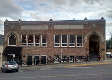
Turn right on Oak Street and then after one block turn left onto 2nd Street. These blocks are in the heart of downtown Hood River and contain lots of shops and restaurants. At the corner of 2nd and State Streets, on your left, is the Hood River City Hall. Originally built in 1920, it was thoroughly restored in the 1990's and returned to a beautiful state.  The corner of State and 2nd Streets is also the beginning point of this walk.

Wednesday, August 12, 2015

Seattle - Portage Bay

Seattle is unparalleled among major American cities for the abundance and beauty of its waterfront areas. The city has is bounded by water to the west (Puget Sound) and east (Lake Washington), and in addition is bisected by Lake Union and the various aspects of the Lake Washington Ship Canal. This walk will take you along one part of the Lake Washington Ship Canal complex of waterways, Lake Union's Portage Bay. The area is dominated by the University of Washington to the north and a variety of waterfront residences and moorages. This walk is 3.3 miles and is fairly level, with a few mild grade changes.


The walk starting point is the Montlake Playfield, located on the south side of Portage Bay, at the end of 15th Street. The walk starts here because nearby free parking is available, unlike along the north side of Portage Bay on or near the University of Washington campus, and also because you can enjoy the waterfront at this point, the view perhaps marred by the SR 520 freeway on a bridge over an arm of Portage Bay. to a pontoon bridge across Lake Washington.

Go along a pathway adjacent to the water to the east (right). Eventually the path will curve away from the water. Then make a sharp left onto this pathway, which leaves the Montlake Playfield toward the Montlake bridge across Portage Bay. Follow the pathway under the SR 520 freeway.


Eventually the pathway merges with a sidewalk on the west side of Montlake Avenue. On your left you will see the large campus of the Northwest Fisheries Science Center, operated by the federal government. After a couple of blocks on Montlake you will use the Montlake Bridge to cross to the north side of Portage Bay. The bridge was constructed in 1925 in a gothic style designed to be in harmony with the University of Washington campus to the north. The bridge can be raised to allow for marine traffic below because it is part of the Lake Washington Ship Canal, the ambitious 1911 maritime project connecting Lake Washington to the Puget Sound. After crossing the bridge you will get a glimpse off to the right of Husky Stadium, home to the University of Washington's football team.

Once you cross the bridge leave the roadway via a trail to the left. At a fork in the path keep to the left and head down the grassy slope toward the water.


To the right you will see a portion of the  University of Washington Medical Center, which has grown from small beginnings in 1959 to become a Pacific Northwest institution. The Medical Center itself is only a small part of the massive University of Washington campus, over 700 acres in size and home to 45,000 undergraduate and graduate students.


Soon you will be at the water's edge. The water in question is the Montlake Cut, connecting Portage Bay on Lake Union with Lake Washington. As the name of Portage Bay suggests, the site of the cut was used by Native Americans to portage boats from Lake Washington to Lake Union. The simple portage was replaced by this waterway, which lowered the level of Lake Washington by nine feet and changed the lake's outlet from its southern end to this point. Today the cut is not used much by  commercial shipping - the most notable users of these waters are now associated with the University of Washington.

Continue along the edge of Portage Bay and enjoy the view across the water.


On your right you will pass the University of Washington Oceanography building, constructed in 1930. The Oceanography department has long outgrown this structure and also occupies two other large buildings along the waterfront. As you continue along the waterfront your path will be blocked by one of the other Oceanography buildings, a more modern behemoth.


At this point turn right and head away from the bay on San Juan Road. Directly ahead is the Magnuson Health Sciences Center. This massive building, at 533,000 square feet, is reputed to be the largest university building in the United States. It is part of the University of Washington medical school complex and is named for long-time U.S. Congressman and Senator Warren Magnuson, who used his seniority to funnel large amounts of federal largesse into the state. If you are visiting at the right time of year you will also enjoy the beautiful cherry blossoms on the trees lining the roadway.

San Juan Road ends at Columbia Road, where you will turn left. Follow Columbia Road as it curves to the right and becomes 15th Street. Monumental university science buildings will be on your right, and views across Portage Bay and its boat marinas will be on your left.


Cross busy Pacific Avenue. On your right is the Physics and Astronomy building, constructed in 1994.


Immediately after crossing Pacific Avenue you will come to the Burke-Gilman trail. Turn left on the trail. This 27-mile paved bike and walking path goes from Lake Union all the way to the suburb of Bothell to the northeast. The route was originally constructed as a rail line in the 1880s. Continue on the trail, watching for speeding cyclists. On your left is Mercer Court, a massive apartment complex for University of Washington graduate students that opened in 2013.


Continue on the Burke-Gilman Trail to the University Bridge over Lake Union. Under the bridge is the Wall of Death, an art installation intended as a tribute to auto, cyclist, and skateboarder stunts. However the work had to be modified in 2008 to prevent its actual stunt use by skateboarders.


Across from the Wall of Death, to the right, are these stairs up to the deck of the University Bridge. Take the stairs and start across Lake Union on the bridge - you will be on the east side of the structure. The bridge dates from 1919 and is a double-leaf bascule crossing (aka a "drawbridge).


As you head across the bridge, to the west you will see the massive Ship Canal Bridge that carries Interstate 5 over Lake Union and Portage Bay. This double-decker was opened in 1962, and soars 182 feet above the water - there is no need for a swing or draw opening to let boats by! The lower deck is exclusively devoted to rush hour express lanes in the morning and evening.


Looking to the northeast, you will see the north side of Portage Bay with many boat docks and marine facilities, and beyond is the University of Washington campus.


To the southeast on the south side of Portage Bay the scene consists of residences hanging over the water (or at least their boat hangars) and houseboat moorages that are floating on the bay.


When you reach the south end of the University Bridge turn left and immediately turn left again. Cross the parking lot to a short pathway that puts you on Portage Place, the street closest to the bay. Turn right on Portage Place. Enjoy the view of the bay to the left between the waterfront homes, which vary greatly in age, size, and design. Portage Bay Place ends in a stairway going up a hill and then veering right to Allison Street. Once on Allison Street go forward to Fuhrman Avenue, where you will turn left.

Fuhrman Avenue curves to the left and becomes Boyer Avenue, following the path of the bay (although there are residences between the street and the bay). Eventually you will pass next to the massive Queen City Yacht Club, with a variety of large pleasure boats under its covered moorages.


After the Queen City Yacht Club you will pass under a bridge for the SR 520 freeway. Just a mile or so to the east this freeway uses the Evergreen Point floating bridge to cross Lake Washington over to Bellevue and Redmond. The freeway and bridge were opened in 1963. Continue on Boyer Avenue to 15th Avenue where you will turn left and return to your starting point at the Montlake Playfield.

Wednesday, July 29, 2015

Lake Oswego - First Addition and Tryon Creek


This walk combines the city and the wilderness. Much of the walk goes through Lake Oswego's First Addition neighborhood, a grid of streets where many modest homes have been either upgraded or replaced with attractive newer homes, most of which remain in scale with the neighborhood. The rest of the walk rambles along the Iron Mountain trail portion of Tryon Creek State Park, where an area logged and burned in the late 19th century has regrown into a peaceful forest. The walk is 3.6 miles long, and it has some ups and downs along its route.


The walk starts as Christ Church Episcopal Parish at the corner of 10th Street and Chandler Road in Lake Oswego. The church has been here since the 1940's and is the second largest Episcopal congregation in Oregon (first is Trinity Cathedral in Northwest Portland).


From the Chandler Road frontage of the church proceed east and then turn left onto 10th Street. On your left is the Oswego Heritage House. This stately landmark at the head of "A" Avenue was constructed in 1920 to serve as the real estate office for the sale of residential lots in and around Oswego Lake. From 1941 to the 1980s it served as a residence and doctor's office. In 1999 it was purchased by the Oswego Heritage Council and restored to its current appearance.

Continue along 10th Street across busy "A" Avenue to "B" Avenue, where you will turn right. On your right, between the sidewalk and the pavement, is an example of a "green streets" landscape strip to collect and absorb stormwater instead of letting it run off and pollute local streams and rivers. "B" Avenue is a typical street in Lake Oswego's First Addition neighborhood, which you are now entering.

Continue on "B" Avenue three blocks to 7th Street, then turn right. 20 years ago the First Addition was one of Lake Oswego's less popular neighborhoods, but its proximity to downtown and its walkable grid of streets have led to a great resurgence in desirability. Walk one block on 7th Street to "A" Avenue. Before you reach the end of the block you will see this house on your right. Until the late 1990's it was located adjacent to Christ Church Episcopal Parish, but was moved to this site when the Church built a new parish hall. It is bordered on both sides by newer, larger houses that were built since its relocation to this site.

At the intersection of 7th Street and "A" Avenue you will see Our Lady of the Lake Catholic Church, another long-time Lake Oswego religious institution. The church's school for Kindergarten through 8th grade is adjacent to the sanctuary. The parish has had a presence in Lake Oswego since 1890, and you will be going by its original home at 1st Street and "E" Avenue later on the route of this walk. The current building on this site was finished in 1956.

At "A" Avenue turn left and head down the street. At 6th and "A" is Kyra's Bake Shop. Started just a few years ago, in 2010-2012 the shop finished first once and second twice in the Food Network's Cupcake Wars. And it won with an entirely gluten-free product, which is the shop specialty. Kyra's story can be found here.


Continue on "A" Avenue another block to 5th Street, where you will turn left. On the corner, in front of a Safeway parking lot, is the Lake Oswego Holiday Tree, lit up every year at Christmas time. The renaming of this tree, formerly known as the "Lake Oswego Christmas Tree," happened 15 years ago, but still sparks occasional controversy and angry letters to the local newspaper over the alleged "War on Christmas" the renaming supposedly represents. Continue on Fifth Street one block to "B" Avenue, then turn right.


Proceed three blocks on "B" Avenue to 2nd Street, then turn left. The next block on 2nd features two large new developments on either side of the street. To the left is a development of condominiums with ground floor "live-work" small commercial spaces associated with some of the residences above. To the right is a four-story residential development of luxury condominiums. Expect to see several more such developments in the downtown Lake Oswego area in the near future.

Continue on 2nd Street for another two blocks to "E" Avenue, then turn right. Go one block on "E" Avenue, then turn right again onto First Street. At the corner is the original 1890 Lake Oswego Roman Catholic church, converted in the 1990s into a single-family residence. It was recently for sale for almost $900,000.


After one block on First Street turn left on "D" Avenue and head one long block down the hill to State Street. On the way you will have a great view of the Willamette River and the Lake Oswego Railroad Bridge. Built in 1910, the bridge serves a couple of freight trains each day. Attempts to get the railroad to agree to a bicycle and pedestrian crossing on this bridge between Lake Oswego and Milwaukie have come to nought.

At State Street turn left and head north. After crossing "E" Avenue you will get to the intersection of State and Terwilliger Parkway. Follow the trail that heads up the left side of Terwilliger. You are now entering Tryon Creek State Park. The trail parallels Terwilliger all the way north to Lewis and Clark Law School, but is far enough from the road that you will hear just a bit of traffic noise. The paved pathway is shared with bicycles, so keep your eyes open, especially looking for speeding bicycles heading in the opposite direction down the hill.


After almost a mile of the paved trail you will see this trail junction to the left with the Iron Mountain Trail. Take the Iron Mountain Trail, and you will soon leave all traces of traffic noise and all potential bicycle conflicts behind. The Iron Mountain Trail traverses Tryon Creek State Park, a 635 acre oasis of nature between Portland and Lake Oswego. After about 1/4 mile you will see an explanatory sign and a mound to the right in the forest. This is the site of old charcoal pit, used in the late 19th century to produce charcoal for the Oregon Iron Company's smelter to the south in what is now Lake Oswego. It's hard to imagine now, but by the time the charcoal makers had finished their work by 1900 this area was a clear-cut wasteland of charred stumps.

Continue on the Iron Mountain Trail. You will soon get to the Iron Mountain bridge, which crosses Tryon Creek. Hikers are advised by signage to stay on the pathway, so that natural vegetation elsewhere can flourish. Tyron Creek usually has water in it, which may come from springs but is also at least partially constituted of urban runoff from surrounding developed areas.


After crossing Tryon Creek you will see, every couple hundred feet, a sewer manhole cover paralleling the trail. Underneath the trail from Tryon Creek to the developed area to the west is a City of Lake Oswego sewer line. It is a clue that this area was not originally intended to be preserved as a nature park. In addition, Iron Mountain Boulevard stubs into the park both at the west end and the east end of this trail. Along with the sewer line, it is evidence that this area could have at one point been developed with a large residential subdivision, and Iron Mountain Boulevard would have traversed the route of this pathway. And in fact the route of this trail approximates the original logging road used by the Oregon Iron Company's charcoal production workers.

Continuing along the trail you will cross another bridge, labeled the "Stone Bridge" on maps, although the bridge appears to be constructed entirely of wood. Soon you will come to a nice bench along the trail, which is dedicated to Pamela Claire Blake. Ms. Blake apparently helped lead the successful efforts to preserve this part of the park.


As you near the edge of Tryon Creek Park you will start so see houses hanging over a slope edge to the right.


Eventually you will exit the park onto Andrews Road. Turn right and go a short distance to Iron Mountain Boulevard, then turn left. Follow the curve of Iron Mountain until it intersects Country Club Road in a very wide, oblique intersection. Cross the intersection and continue on Iron Mountain - the intersection is an all-way stop, so the cars should stop for you. Follow Iron Mountain south to its intersection with Chandler Road, then turn left and return to your starting point at Christ Church.

About Me

Blogs about biking and walking in the Pacific Northwest