Hood River is a small city in a spectacular setting - the heart of the Columbia River Gorge. The hillside setting provides great views of the river and gorge, which you will see a lot of from the route of this 2.2-mile walk as it traverses up and down the city's hillside (including a 413-riser stairway!). A car trip up the Hood River Valley will take you through some of the nation's best apple and pear orchards, and eventually to Mt. Hood itself. The gorge and mountain are location to many spectacular nature walks, so this city walk might be a nice change of pace for frequent visitors or vacationers.
Our walk begins at this waterfall on State Street, at the south end of 2nd Street (at least the south end of the vehicular travel way!). Take a look up the steep hill - you will become very familiar with it in the near future!
Head up the first flight of steps next to the Big Horse building. On your right is Stratton
Gardens, opened in 2002, which transformed a 6,000 square foot lot into a pretty little public garden.
Continue up the hill. If you aren't already tired, you soon will be, but the climb will be worth it. The Second Street Stairs, also known as Gil's Stairs (named for long-time City Councilor Gil Jubitz), have 413 steps, making them one of the longest public stairways in the United States. I suppose one could argue that, since the stairway is intersected by five streets, it isn't really a continuous stairway. But consider the intervening streets to be landings, allowing you to rest before continuing up, and up, and up. While the current stairs were constructed in the 1940's, earlier versions date from the
early 20th century. If you need to take a break, turn around and enjoy the panoramic views of the Columbia River.
Eventually you will reach the top of the stairs at Montello Avenue. To your left is this beautiful old hilltop home, built in 1900 with spacious grounds overlooking the city.
Turn right on Montello Avenue and proceed west, enjoying the views to the right of the city and the river. There are many old, attractive residences along this street. At the corner of 9th and Montello is the historic
Simpson-Copple house, built in 1906 in the vernacular late Queen Anne architectural style. It is on the National Register of Historic Places.
At 9th Avenue turn right and use the stairway to start back down the hill (it's a lot shorter than the 2nd Street stairs). The narrow green space along the downhill side of Montello Avenue is actually a city park. Gracing the stair landing is this little statue of a batter. Continue to the end of the stairway on Eugene Street and then turn left. On your right is the Hood River Children's Park, with an attractive play area.
At 9th Street make a slight dogleg to the right and then continue to the left on Eugene Street. On the left side of the next block is the old Coe Primary School building, now the district offices of the Hood River County School District. The building is the oldest elementary school building still standing in Hood River, built in 1915.
Continue on Eugene Street. On the corner of Eugene and 11th Street, on the right, is St
. Marks Episcopal Church. The church moved to this building in 1925, and according to
this report one of the parishioners at the time, Captain C.A. Schetky, was reputed to be the oldest living Episcopalian in the U.S., and had been blessed at the altar when four years old by the chaplain of the Continental Congress and first Bishop of Pennsylvania.
Continue on Eugene Street one more block to 12th Street. On the left at the corner is the
Inn at the Gorge, a bed-and-breakfast establishment in a 1908 Queen Anne-style home.
At 12th Street turn right and proceed down the hill again. After two blocks turn right again onto State Street. This street is lined with beautiful old historic houses such as this one on the uphill (right) side.
The walk along State Street also provides some more glimpses down the hill to the Columbia River. The river here is actually now a lake behind the massive Bonneville Dam, 25 miles to the west.
Continuing along State Street you will enter into the downtown area. At 6th and State Streets, on the left, is the Asbury United Methodist Church. However the congregation that used to be here has combined with a Lutheran congregation and has relocated to the former Lutheran facility in another part of town. So this grand old church, constructed in 1912, has an uncertain future.
After crossing 6th you will get to a trail on the left side of the street leading down the hill. Before you take this trail, note that immediately beyond is the Hood River County Public Library. Originally constructed in 1914 as a Carnegie Free Library, the building has a modern expansion on its right side. Unlike most Carnegie Libraries this one was built on a hillside, and so has a somewhat different architectural plan from other old Carnegie Libraries.
Take the trail down the hill into Georgiana Smith Park, a nice little hillside landscaped area. The park opened to the public in 2005. It is named for Ms. Smith, daughter of a Hood River pioneer family who was instrumental in getting the original Carnegie Library located and constructed over 100 years ago. At the fork in the pathway take the path to the left, back toward 6th Street.
The path will empty onto 6th Street right above Oak Street. Go to Oak Street and turn left, then turn right on 7th Street. Continue two blocks south to Columbia Street. Before reaching Columbia look to the right, and you will see the back sides of some new condominiums constructed to maximize views of the Columbia River. Hood River has seen a surge of new construction for wealthier individuals, either for primary or secondary residences. This kind of construction is changing the nature of the city's downtown, and also the city as a whole.
At Columbia Street turn right. On your left will be the
Full Sail Brewery, Hood River's largest and most well-known. Full Sail has been located here since it was founded in 1987 on the site of a former cannery that had been closed since 1972. Inside, the brewpub and restaurant have astounding views of the Columbia River below.
Continue on Columbia Street to 4th Street, then turn right. On your right is another Hood River microbrewery,
Double Mountain. This brewery began operations in 2007. It also has a taproom and restaurant for you to enjoy. A third great microbrewery in Hood River,
Pfriem Brewers, is located on the Columbia River waterfront, and also serves some delicious beverages. There are four total breweries in a town of 7,400 residents - a very good ratio for beer lovers!
After one block on 4th Street turn left onto Cascade Street and go forward one block to 3rd Street. At the corner of 3rd and Cascade, to the right, is the Heilbronner Block, a commercial building on the National Register of Historic Places that was constructed in 1910. The building originally included a community hall on its Third Floor which was apparently the home of a local chapter of the
Knights of Pythias.
Turn left onto Third Street and go one block to Columbia Street. Turn right onto Industrial and go to its end, where you will see a pathway under the 2nd Street bridge. Use the pathway to get to the other side. On the right, down the hill, is the Oregon-Washington Railroad and Navigation Company Passenger Station, which serves as the terminus of the Mt. Hood Railroad and formerly also served the Union Pacific Railway in town. The Union Pacific mainline, with frequent long freight train traffic, is below the station. The station, constructed in 1911, is on the National Register of Historic Places.
Often the passenger station yard will have a beautifully restored railway car used by the
Mt. Hood Railroad for its passenger excursions up the Hood River Valley. The 22-mile line also offers local freight service.
At 1st Street turn right and head back up the hill past Cascade Street to Oak Street. To the right, on the corner of 1st and Oak is the Mt. Hood Hotel Annex. Constructed in 1911, it is on the National Register of Historic Places. The building is still used for guest accommodations.
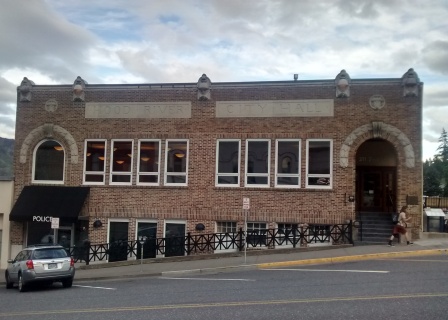
Turn right on Oak Street and then after one block turn left onto 2nd Street. These blocks are in the heart of downtown Hood River and contain lots of shops and restaurants. At the corner of 2nd and State Streets, on your left, is the Hood River City Hall. Originally built in 1920, it was thoroughly restored in the 1990's and returned to a beautiful state. The corner of State and 2nd Streets is also the beginning point of this walk.