Friday, February 27, 2015

Mt. Tabor

Portland's Mt. Tabor neighborhood is named for the extinct volcanic  cinder cone that rises 636 feet in elevation in its middle. The "mountain" itself is a park (with a large city reservoir system included), but is surrounded by a residential community. The western portion of the Mt. Tabor neighborhood, in the direction of downtown Portland, includes lots of grand old homes and historic structures to enjoy looking at. This walk, 2.8 miles long, will take you by many of these architectural treasures, and it will also include a journey to the lower reaches of the Mt. Tabor Park. The route includes moderate ups and downs, especially in the portion within the park.


This walk begins at the Mt. Tabor Presbyterian Church, located at the intersection of SE Belmont Street and SE 55th Avenue. While the church has been located at this site since 1892, this building was constructed in 1910. The ever-popular (at the time) bell tower designed to look like a romanticized medieval castle turret dominates the structure. The church has made great efforts in recent years to reach out to the community in different ways, efforts that are chronicled on the church's website.

Cross Belmont Street to the east side of SE 55th Avenue. At the corner is the Irvington Masonic Lodge building, which according to a plaque in the front was constructed in 1952 - it looks much older. There is no sign of continued masonic use of the building, which is not surprising given the steep decline in Masonic membership in the U.S. over the past several decades. Although no signs indicate it, the building now houses the Mt. Hood Model Engineers Club, dedicated to the creation and maintenance of model trains.


From the Masonic Lodge building continue south on 55th Avenue. This street contains a number of fine old homes. This one on the right between Taylor and Salmon Streets, built in 1900, is located on a lot almost one acre in size, and now houses the Vedanta Society of Portland. Vedanta philosophy claims to be the foundation of Hinduism. The leaders of the society are known as Swamis. The current leader in Portland is Swami Shantarupananda.

Continuing along SE 55th Avenue, on the left between Salmon and Madison is the Samuel Cobb House, a large craftsman-style home constructed in 1911. It is on the National Register of Historic Places. Samuel Cobb was a prosperous Portland sawmill owner who designed and built the house himself. Among the beautiful craftsman interior finishes are seven fireplaces.

The next block on the left, between Madison and Hawthorne, is home to the Western Theological Seminary Portland branch. The seminary describes itself as "a theologically conservative graduate school that promotes true innovation and humility in ministry practice. The Bible is God's inerrant Word and we set it at the center of our curriculum in the belief that faith and practice must be driven by principled interpretation and integration of the scriptures." However the house itself is located on the site of the first home in the area, constructed by pioneer Peter Prettyman in 1846, at the head of Hawthorne Street. The current house was constructed by Philip Buehner in the first decade of the 20th century. A history of the site and the house can be found here

At Hawthorne Street, after passing the Seminary building, turn left. Go five blocks through the neighborhood to 60th Avenue, where you should carefully cross this busy street. turn right, and after a few hundred feet you will see this stairway on the left. Take it up to the turret above, which you will soon see is part of the Mt. Tabor water reservoir.


At the top of the steps you will see the main reservoir. Before turning right to go around the reservoir, note this sign. Perhaps what this guy did doesn't qualify as "throwing things," but the whole incident created quite a stir! The reservoirs themselves must be decommissioned from holding city drinking water, but the fate of the reservoirs after they are drained of drinking water is still being decided by the city. And some in the area are still fighting any kind of reservoir closure.


At the corner of the reservoir turn left and continue around it. At the next corner, veer to the right away from the reservoir and start heading up a roadway, which is really a paved trail. Keep going up the hill on the gradual slope, and stay off the more developed roadway you will see below you. Mt. Tabor, for those who are interested, is an extinct volcano cinder cone. It is 636 feet in elevation - however, this hike doesn't take you to its top.


Eventually you will see ahead in the distance the maintenance building for the Mt. Tabor upper reservoir. A trail will veer to the right - take it and start heading down the hill. Eventually you will see this plank wooden stairway heading down the hill to the right. Take the stairs. At the bottom of the first set of stairs is the Mt. Tabor off-leash dog park. If you were to continue down the stairs, you would reach the campus of Warner Pacific College.


However at the end of the first set of stairs turn right and travel through the off-leash dog park. Eventually you will get to this gate. Go through the gate and turn left on the roadway, and then quickly right onto SE Lincoln Street. Ahead is a long strip of park land with a street and homes on each side. On one side (to the right) are older Mt. Tabor neighborhood homes, on the other (to the left) are homes that were built in the late 1980's.


On this park block you will soon pass by this community garden. There are 50 of these community gardens located on Portland City park land throughout the city.


Continue to the west end of the park strip and then cross 60th Avenue at Lincoln Street. Continue west on Lincoln Street. At the corner of 54th and Lincoln, on the left is the Lincoln Street Kayak and Canoe Museum. The Museum is open on Wednesday from 5 to 7 PM, and admission is free. It looks like a great place to visit if you are interested in kayaks and canoes.


Turn right onto 54th Avenue. The next long block has a good variety of housing types from the early 20th century. This purple house on the left exemplifies the two-story "bungalow" style, with a dormered second story and a generous front porch. Next to this house on the left is a 1982 addition to the neighborhood, very much out of character architecturally.


When you get to Hawthorne Blvd. take a left, but first glance to the right and you will see a block away the imposing Western Seminary mansion that you passed earlier along the route. Quickly turn right onto SW 53rd Avenue. At 53rd and Salmon, to the right, is this impressive 1911 home.


Continue on 53rd Avenue. On the left, one house before the intersection of 53rd and Taylor, is this home built in a traditional early-20th-Century style. But it has that "new" look. Another tell-tale sign: if you look closely the house appears to have no basement windows, and therefore no basement. In fact, this house was constructed in 2010. It is much more respectful of neighborhood architectural traditions than the houses plopped into neighborhoods like this from the 1960's through the 1980's.


At Taylor turn left, and then turn quickly to the right to get back on the next leg of 53rd Avenue. Continue one block to Belmont Street. On the left is this structure on the National Register of Historic Places, the Blaine Smith house. It sits on a lot of almost 1/2 acre. The Arts and Crafts-style home was built in 1909.


Cross Belmont Street and continue north to Morrison Street, where you will turn right. On the right at the corner of 54th and Morrison is the Brainard House. This Victorian-style home has been here since 1888. It is also on the National Register of Historic Places.


On the left, diagonally across the intersection from the Brainard House, is another grand Victorian-era home. This one was built in 1890, but is not on the National Register.

Continue one more block to 55th Avenue, then turn right, and you will be back at your starting point for this walk.

Monday, February 2, 2015

Salem - Deepwood Estate and Bush's Pasture Park

Oregon's State Capitol city, often derided as a dull place, is actually, once you scratch the surface, a city with lots of interesting sights and activities. This walk will take you south of the State Capitol, through the Willamette University Campus, to the Historic Deepwood Estate and Bush's Pasture Park before returning through Salem's public hospital and the University campus to the Capitol building. There's lots of interesting architecture to look at along the route. The walk is 2.6 miles long, and has one significant hill n the neighborhood south of Bush's Pasture Park.


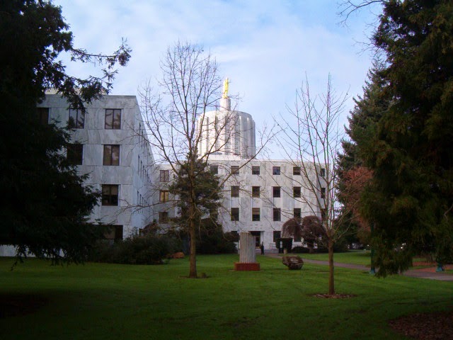
This walk starts at the beautiful Oregon State Capitol, constructed in 1938 after the previous capitol building burned to the ground in 1935. The part of the building in the foreground in this photo is actually one of two major 1977 additions, one on either side of the original building. This side is occupied by State Senators and their staffs. The entire building is scheduled to be vacated for over a year after the 2015 legislative session to accommodate a major seismic upgrade.

Start at the State Street side of the Capitol and turn left. Cross at the crosswalk near the intersection of State and Waverly to the Willamette University campus on the south side of State Street. The first building you will see is the newest major building on campus, Ford Hall. Named for major contributor Hallie Ford (she also has the university art museum named for her), the building was completed in 2009 and houses several university liberal arts programs.

Walk to the right of the Ford Center, and then continue to the right of the next building, Smullin Hall, which houses Willamette's information technology functions. Once past Smullin Hall turn left, and to your right will be the Pelton Theater, guarded by two lions out front. The theater was completed in 1923.


Once past the Pelton Theater and the parking lot next to it, turn right. Continue to a bridge over Mill Race Stream. Immediately beyond is the Martha Springer Botanical Garden, opened in 1998 as a tribute to a long-time biology professor. The small one-acre garden includes 12 micro-gardens. Mill Race is a diversion from Mill Creek to Mission Creek that provided water power to the Thomas Kay Woolen Mill located upstream from this location as well as several other long-ago departed industrial enterprises.

After crossing Mill Race and looking at the botanical garden veer right and and then go straight ahead. On your right is the Mark Hatfield Library and on the left is the Sparks Athletic Center. Once you get to the parking area turn left along the sidewalk and pass by the front of the Sparks Center. Continue to the right along the side of a soccer field until you get to Bellevue Street.

Turn left onto Bellevue, and after one block use the crosswalk to turn right on 12th Street. As you proceed south you will see, in the distance to the left, Salem's Amtrak Station, a beautiful Beaux-Arts style building constructed in 1918. Continue along this busy, undistinguished section of 12th Street, to Mission Street. You will pass by the popular Ram pub as well as a bridge over "Mission Creek" (about which more will be said later on the walk).

After you cross Mission Street the scenery takes a turn for the better. To the right is the Historic Deepwood Estate. This four-acre site is owned by the City of Salem as a public park, but the 1894 Queen Anne-style mansion is managed by Friends of Deepwood Estate, who provide organized tours of the home. The estate was given its name by Alice Powell, its final owner before the City acquired the property in 1971.


The estate is much more than just the grand mansion - the four acres of grounds also include beautiful gardens and a greenhouse that are open for free to the public. It is worth your time to wander through the gardens to admire the flora.


After you walk around and enjoy the Deepwood Estate grounds, go back onto 12th Street. After passing Lee Street, turn right onto Waller Street. After a block of ordinary apartment buildings you will come to this bridge, which crosses Pringle Creek. Use the bridge to cross the creek, then turn left onto the pathway.

You are now entering Bush's Pasture Park, a 90-acre greenspace. A stroll through the western half of the park is included on this walk - our route will go through the eastern part of the park. Continue past the trees into a large open grassy area, with trails that see a lot of use by joggers. Continue to the edge of the park at Leffelle Street, then turn right onto Leffelle (or stay on the pathway at the edge of the park which parallels Leffelle).
The neighborhood south of Bush's Pasture Park contains a number of old, attractive houses, such as this bungalow-style home, built in 1920, at the corner of Leffelle and Davidson.


Continue on Leffelle to its end at Summer Street, then turn left. Go one block and then turn right onto Cross Street. Go up a short hill on the next block, and at the top of the hill, after crossing Winter Street, is this stately Georgian-style home, built in 1934 for Custer Ross, a prominent local attorney. The American elm tree in front of the house is a lot older, dating from 1890, and is a Salem Heritage Tree

At Cottage Street turn right, and after one block you will reenter Bush's Pasture Park. Continue on the park trail that veers slightly to the left, on level terrain. When this path T's into another walking path turn right, and start going down a hill.


As you start on this path down the hill, to the right you will see this statue. It is entitled "Guidance of Youth," and depicts a pioneer family resolutely striding forward, presumably toward Oregon on the Oregon Trail. It was commissioned and placed on this spot in 1959 to commemorate the centennial of Oregon's admission as a state to the Union. Not mentioned on the plaque to the back of the statue is its interesting back story. It was commissioned and paid for with a $34,000 bequest from Carroll Moores, an evidently very thrifty janitor for the Oregon Supreme Court building. An earlier idea to use the money to purchase a painting of a nude by Auguste Renoir was the subject of significant local controversy, and was rejected.


After viewing the statue return to the trail and continue down the hill. You will be leaving the forested portion of the park and heading back into the grassy field portion of Bush's Pasture Park, but the last of the trees is this beautiful deciduous specimen.

At the bottom of the hill continue on the trail to the left. You will skirt the perimeter of the Willamette University baseball field and the University's McCulloch football stadium. The Willamette Bearcats participate in the NCAA at the Division III level. While the Bearcats don't have the consistent level of football excellence found at rival Northwest Conference foe Linfield College in McMinnville, the school plays at a generally high level, last winning the conference championship in 2008.

As you pass by the football stadium the trail branches. At the first branch go to the left, and almost immediately the trail will branch again - at this point, go to the right. You will be heading for the intersection of Mission Street and Winter Street. Cross Mission at the signal light, and proceed up Winter Street. You will soon be in going through the massive Salem Hospital campus. Salem Hospital is the only major public hospital in the city. Its recent plans to expand westward to Church Street has engendered some local controversy.

At the north end of the Salem Hospital campus, between the hospital and Bellevue Street, you will pass over this waterway (earlier you passed over it while on 12th Street near the Ram Restaurant). It is shown on some maps as Mission Creek, but it is actually the Shelton Ditch, a diversion canal from Mill Creek to Pringle Creek originally constructed in the mid-19th century. It is part of the complex set of creeks and ditches serving Salem with water that is for the most part diverted from the Santiam River to the south.

After Sheldon Ditch, you will cross busy Bellevue Street and continue north on Winter Street. You are now back at the edge of the Willamette University campus. On the left side of Winter, across from the main campus, is the Willamette University College of Law. The college is one of three law schools in Oregon, and has a healthy rivalry with the University of Oregon and Lewis and Clark law schools. The law school's main building, the Truman Wesley Collins Legal Center, was built in 1967,


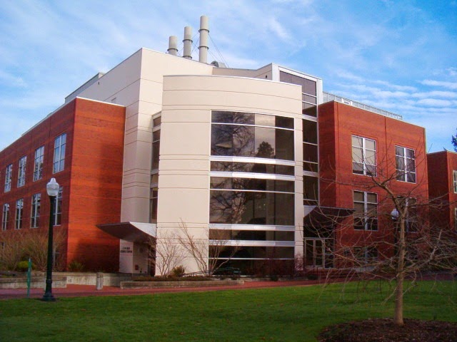
To the right on Winter Street, before its intersection with State Street, is the Olin Science Center, constructed in 1995 and housing Willamette's biology and chemistry departments. 


Continue on Winter Street until it tees into State Street. On the block to the left are a series of interesting buildings. On the corner is the Civic Justice Center, home of the Oregon Law Commission, which inhabits Salem's 1912 Carnegie Library, with a classic beaux arts style used in many such libraries around the world. It served as Salem's public library until 1971, then was used by the YWCA until 2008, when it was refurbished by the law school and dedicated by none other than Supreme Court Justice Ruth Bader Ginsburg. Next on the block is the modern-style YWCA building, which has now been vacated by the YWCA, constructed in 1954. The architect was Pietro Belluschi. Next down is the art-deco style Pacific Telephone and Telegraph building, now occupied by CenturyLink, built in 1930. Finally, on the corner of State and Cottage, is the Hallie Ford Museum of Art, opened by Willamette University in 1998, with an excellent collection.

After taking a look at these buildings, turn right on State Street and return to the State Capitol. You will pass by the other 1977 addition to the original capitol, which primarily is occupied by members of the State House of Representatives and their staffs.

Friday, January 9, 2015

Lower Washington Park - SW Portland

On the hill west of downtown Portland, Washington Park is a 410-acre green space with some of Portland's most notable attractions, including the Oregon Zoo, International Rose Test Garden, and Japanese Garden. But the park includes a number of lesser-known sights, all within walking distance from the Goose Hollow and King's Hill neighborhoods to the east. This walk starts in the neighborhood, winds up to see some sights in the lower part of Washington Park, and then returns downhill. It is slightly more than 2 miles long.


This walk starts at the Multnomah Athletic Club (MAC), located on Salmon Street between 18th and 20th Avenues. This well-known civic institution was formed in 1891 and moved to this site in 1912. The original clubhouse was demolished in the 1960's and replaced by this 8-level structure on the north side of Salmon Street, connected by a pedestrian bridge with a 600-space parking structure on the south side. The home of the Portland Timbers, 20,000-seat Providence Park, was built by the club in 1926, then sold to the City of Portland four decades later. The club retains its own private seating section at the south end of the stadium, which is right to the north of the MAC building.

Start up the hill on Salmon Street. At the corner of Salmon and 20th, to the right, is this large apartment building, constructed in 1951. It is one of several high rise apartment and condominium buildings in King's Hill. Views of downtown Portland, the Willamette, and east all the way to Mt. Hood, are undoubtedly spectacular.


Turn right on 20th Avenue and start down the hill. You will soon be in the Goose Hollow neighborhood, which fronts along Canyon Road. The neighborhood is a mixture of all sorts of housing types, and has a station on Portland's MAX light rail system. The neighborhood is seeing significant new construction, as exemplified by this building (in yellow) going up at Canyon Road and 20th Avenue (picture taken in December, 2014).

Turn right on Canyon Road. Before construction of the Vista Ridge Tunnel for the SR 26 freeway in 1970 (to the south of this spot) this was the primary access from downtown Portland to and from Beaverton and Washington County. It still carries quite a bit of traffic to its intersection with the freeway a mile to the west. The massive Vista Bridge, connecting King's Hill with Council Crest to the south was constructed in 1926. Unfortunately, this beautiful bridge has become a magnet for suicide jumpers, and a group has organized to support the city in its recent completion of suicide prevention barriers.

As you walk west on the south side of Canyon Road note the MAX tracks on the other side of the street, which disappear into the three-mile long Robertson Tunnel, taking the trains to Beaverton and Hillsboro. But on the right side of the street, right after you cross under the Vista Bridge, you will see this path veering into Washington Park, where your walk will become much quieter very quickly!

As you walk up the path into Washington County, you will soon come across one of the city's iconic Benson Bubblers, water fountains that continuously spout fresh water for thirsty passers-by. But what, you ask, is a Benson Bubbler doing outside of downtown Portland? The answer is that this is not a real Benson Bubbler! The only real Benson Bubblers have four bowls on a single pedestal and are limited to the downtown walking area. This is just an ordinary continuously-flowing (with fresh water) Portland drinking fountain. Still pretty unique!


Follow the winding, paved pathway up the hill into Washington Park. On your right, down the hill, you will see the City of Portland's Water Reservoir #4. In this picture it has been drained as a precursor to the city's project to cover it up. This is the final result of a long battle between Portland and the U.S. Environmental Protection Agency regarding the city's uncovered reservoirs in Washington Park and on the slopes of Mt. Tabor. There are still some holdouts regarding the Mt. Tabor reservoirs. The hopes of the holdouts haven't been helped by some recent stories regarding open reservoir contamination.

After several hairpin turns the path will take you to this block house and fence, which is the entry to Washington Park Reservoir #3. This one is also being reconstructed and covered. Take the stairway up the slope to the right.


At the top of the stairway you will come out onto one of the park's roadways. Walk on the left of the roadway - to the right will be Reservoir #3. Eventually, on your left, you will see this fountain. It is the Chiming Fountain, installed here way back in 1881, originally used for the watering of horses. A statue of Cupid at the top, part of the original fountain sculpture, is long gone.

Continue up slope on the park roadway until you see these houses ahead. A sign on the right guides you to the Oregon Holocaust Memorial. The Memorial was dedicated in 2004, but originally approved in 1995. Astoundingly, the Arlington Heights Neighborhood Association (the neighborhood that these houses are part of) appealed the decision to the Oregon Land Use Board of Appeals and managed to hold up construction for over six years! The neighborhood association believed that the memorial would generate too much traffic and noise in the neighborhood - a concern that has, putting it mildly, not been borne out by events since 2004.

Turn right beyond the sign and enter into the Holocaust Memorial. The first thing to catch your eye will be these items lying on the ground - a metal suitcase and violin. They represent the interruption of regular life and the everyday items left behind when the Holocaust's victims were deported to meet their fate.


Beyond the cobblestones is this memorial wall. It contains history panels, including quotes from Holocaust survivors. Beyond the wall is a soil vault, containing ashes from the major factories of death in Poland, such as Auschwitz and Treblinka. On the back of the wall are the engraved names of Holocaust victims, followed by the names of their surviving relatives in the Pacific Northwest.


Continue the walk going to the left of the Holocaust Memorial. You will cross a small parking lot and a picnic area. Continue to the left, toward the rear of the parking lot, and you will eventually get to this statue, entitled "The Coming of the White Man." It was sculpted and placed on this site in 1904, and it depicts two Native Americans, one of whom is Chief Multnomah, looking east to the Columbia River, where the Lewis and Clark Expedition came from one hundred years earlier. It's romanticized view of its subjects, and whole point of view represented, are definitely not those of today.


From the statue, continue forward and head down a slope. You will cross a roadway and then come to a pathway that parallels the road below. Turn right onto the pathway.


After several hundred feet you will come to an intersection of roadways and paths. Turn left and follow the roadway. To your right you will see the Chiming Fountain again. Once past the fountain, you will see this paved pedestrian path leave the roadway to the right. Take the pathway, which will bring you to the main lower entrance to Washington Park.


Follow the path to the Lewis and Clark column, whose cornerstone was laid by Theodore Roosevelt in 1903, and which was completed in 1908. It is the first picture at the top of this blog post. From this vantage point you can see the wide walkway leading back into the city to the right. Take the walkway and leave Washington Park.


When you reach the Washington Park entrance gate take the roadway to the left. You will walk behind a large apartment complex with a feature that is rare for such complexes in the Pacific Northwest - an outdoor pool, or at least an outdoor pool that isn't covered with a tarp for the winter. It's hard to imagine anyone using this pool from early October to late April, but perhaps some hardy souls in the complex brave the elements.


Immediately after the pool you will see this trail leaving the roadway to the right. Take the trail down the hill, and then turn left onto SW Cedar Street. This is a great neighborhood of older and newer homes.


Cedar Street ends in a stairway heading down the hill to SW Cactus Drive. Take the stairway.


At the bottom of the stairway follow Cactus Drive as it curves to the right. On your left is the Envoy Building. Constructed in 1929, it contains 43 units, formerly apartments, converted to condominiums in 2004. While the building has five stories on this side, on the downhill side it is seven stories tall. The building sits on a high slope above West Burnside on its other side, and the units have panoramic views to the north and northeast. The building is on the National Register of Historic Places.


Continue on Cactus Drive. Right beyond the Envoy Building you will get a glimpse of some of the views that residents of the building enjoy.


Follow Cactus Drive, enjoying the views to the left, until you reach a three-way intersection with Cedar Street and Green Avenue. Veer slightly to the right onto Green Avenue. On the right is this stately home in a Greek Revival style (also popular with antebellum Southern plantation houses). It was built in 1907.


At Park Place, turn left. Cross Vista Avenue and on the next block are older high-rise apartment buildings. Cross St. Clair Avenue, and on your left will be a one-story building, with garden out front, belonging to the Oregon Society of Artists. The Society began operation in 1927, but built this home for itself in 1955. The Society's members are artists, but it's unclear from its web page how an artist gets into the society. Events are open to the public on the first Thursday evening of each month, consisting of an "artist's demonstration."


Continue on Park Place to King Avenue, where you will turn right. On the right corner is this attractive brick house, built in 1904, which includes a second large building on the same lot (to the left in the picture). After a very short distance on King Avenue turn left onto Salmon Street.


On this block of Salmon, to your right are several attractive older homes. To your left is a sunken garden area, followed by this building, the Town Club. The club was established in 1928, and describes itself as a "women's private club." The building and grounds are used to host various social gatherings for the members and their guests. Of note is the dress code, which reads like a relic from another era, with its admonition that, for both men and women, "no casual attire of any kind" is allowed.

Continue on Salmon to 20th Avenue, where you will see the Multnomah Athletic Club again and reach the starting point of this walk.

About Me

Blogs about biking and walking in the Pacific Northwest