Portland's South Waterfront area has seen dramatic changes in the past 20 years. A former waterfront industrial area south of the I-5 Marquam Bridge is now a bustling hub of hipster business and residential activity. The recent opening of the landmark Tilikum Bridge over the Willamette, available to all forms of traffic except motor vehicles, has opened up new vistas and provided new routes for walking. A pedestrian bridge over I-5 from the South Waterfront connecting with the Lair Hill neighborhood to the west has ended an awful choice pedestrians used to have to make between walking a couple miles out of the way or taking their lives into their hands navigating the Ross Island Bridge approaches. This 3.5 mile loop also goes through an interesting historic slice of Portland - the South Auditorium urban renewal district, now a mixture of 1970's modernism and the early 21st century reworking of that modernism. Also featured are the century-old Hawthorne Bridge and the Oregon Museum of Science and Industry. This route is packed with interesting things to see and experience!


The walk begins at the corner of SW Corbett Ave. and SW Gibbs St. in the Lair Hill neighborhood. The walk starts here because, unlike most of the route, street parking is free. There is a two-hour limit during weekday daylight hours, and no limits for the rest of the week. From the intersection turn north toward downtown and follow Corbett as it veers to the left (there is a name change to Grover Street). You will soon see this pedestrian tunnel under Naito Parkway, paralleling the street. The tunnel is well-lighted, and any alternative route would require you to cross busy Naito Parkway at an unsignalized intersection, but still, be alert as you go through the tunnel.
After going through the tunnel Grover Street curves to the right and becomes First Avenue. At the first left turn onto Woods Street. This 1889 Victorian home on the corner has been converted into a triplex condominium, and looks well cared-for.
After one block turn right onto Second Avenue. At the corner, to the right, is the
Cedarwood Waldorf School. The school, part of a nationwide network of private schools implementing the teaching philosophy of
Rudolph Steiner, is located in a building from 1910, known as the
Neighborhood House. The Neighborhood House was a Settlement House, built by the National Council of Jewish Women. Settlement houses served as social welfare organizations in the days prior to government social welfare programs. Lair Hill and South Portland, the route of much of this walk, was the center of Portland's Jewish community in the early 20th century.
Across the street from the Waldorf School is
Lair Hill Park. One would think that the Lair Hill neighborhood, and this park, were named after a Mr. Lair, since the site is elevated above the river and downtown. However, the neighborhood is actually named after Mr.
William Lair Hill. Among its other attributes the park contains a Carnegie Library, now used for recreation programs.
Continue three blocks on Second Avenue to Meade Street, then turn right. On the corner of Meade and Second is this former church, built in 1900, that is now a single-family residence. While originally a church, for almost a century it was the home to the
Kesser Israel Orthodox Jewish congregation, which occupied the building until 2008.
Continue one block on Meade to First Avenue, then turn left. Across the street are two charming Victorian homes from the late 19th century. The remnants of the old South Portland neighborhood such as this make us mourn its loss in a different time, when existing neighborhoods were considered dilapidated and worthy only of demolition, rather than charming and worthy of preservation.
Continue on First Avenue across a signalized intersection at Arthur Street to the first major disrupter of the South Portland neighborhood, the
I-405, or Stadium, freeway. Construction began in 1964 and finished when the Fremont Bridge over the Willamette connected to I-5 at its northern end in 1973. The freeway provides a loop from I-5, connecting to the Highway 26 freeway to the west and U.S. 30 to the northwest.
Concurrent with I-405's swath through South Portland the neighborhood was the site of Portland's largest urban renewal effort in the 1960's and 1970's, a 110-acre complete demolition and rebuild of what was known as the
South Auditorium District. As you continue north on First Avenue you will see the classic results of mid-20th century urban renewal, "
towers in the park." The block on the west side of First Avenue, north of I-405, contains several residential towers built in the 1970's in a classic "international" modernist style.
Continue on First Avenue to Lincoln Street, then turn left, after crossing the street. This street is home to Portland's newest light rail line, the Orange Line from downtown Portland to Milwaukie. Lincoln Street's look has
changed quite a bit since the line started a couple of years ago, but the controversy over removal of trees in the center of the street seems to have disappeared.
As you continue along Lincoln Street you will soon come to the Linc, a newer addition to the apartments and condos in South Portland. The Linc, having been built after the turn of the 21st century, is architecturally quite different from the "towers in the park" that were built as part of the South Portland urban renewal project several decades earlier. The Linc is a great example of the maxing out of wood-frame buildings at
six stories, based upon generally accepted building codes. Going higher requires steel or concrete construction, which is much more expensive. So central Portland is filling up with six-story apartment buildings, like the Linc, as a result.
After passing the Linc you will see this wide pathway to the right of Lincoln Avenue. It approximates where Third Street used to run before the South Auditorium urban renewal project changed the street pattern forever in this area. Turn right and follow the pathway.
The pathway runs between residential buildings to the right and the backs of Portland State University campus buildings to the left. Eventually to the right you will come across
Lovejoy Fountain Park. This centerpiece of the South Auditorium redevelopment project was designed by famous landscape architect
Lawrence Halprin.
Continuing north on the pathway, you are headed toward the
KOIN center, still several blocks north. Constructed in 1984, the building was the focus of short-lived controversy because it blocked the view of Mount Hood visible for motorists exiting the Vista Ridge Tunnel on the U.S. 26 freeway a couple of miles to the west. The building is named for KOIN-TV, the CBS affiliate in Portland, which has its studios located in the building. The upper floors are taken up by luxury condominiums.
Continue on the pathway to Market Street, and after crossing Market you will be on Third Avenue. To the right is the Keller Auditorium, originally the Civic Auditorium, in this location since 1917, but extensively redone in a bland modernist style in 1966. It hosts opera, ballet, and traveling Broadway musicals, but no longer the Oregon Symphony, which moved to the Arlene Schnitzer Concert Hall (a glorious repurposed old 1920's movie theater) in 1984. But the chief attraction here is to the left - the
Ira Keller Fountain, which takes up a whole city block. Opened in 1970, the fountain was also designed by Lawrence Halprin.
Continue on Third Avenue across Clay Street. On your right is the KOIN Tower. Continue another two blocks to Jefferson Street. On your left is
Terry Schrunk Plaza, named for the long-time Mayor of Portland from 1957 to 1973. On the far (west) side of the Plaza is the Italian Renaissance-style Portland City Hall, constructed in 1895. Schrunk Plaza is actually owned by the Federal Government, because it covers an underground parking garage built in conjunction with the federal building across Third Avenue to the right. This became an issue in 2011 when Occupy Portland protesters moved into the plaza and
were promptly booted out, as opposed to a more tolerant city attitude in the two park square blocks to the north of Schrunk Plaza.
To the right on Third Avenue are three blocks devoted to large government buildings. First is the Edith Green-Wendell Wyatt federal building, constructed in 1975 and given a new more interesting facade in 2009. Green and Wyatt were two long-time Oregon congresspersons from the middle of the 20th century. Next is the Multnomah County Justice Building, which contains among other users the County Jail and the Portland Police Bureau headquarters. It does not include the County Courts, which are in an historic building to the west. Finally, farthest away is the
Mark O. Hatfield courthouse, named for Oregon's long-time U.S. Senator and former Governor, opened in 1997. Its tenants include the U.S. District Court for Oregon and Ninth Circuit Court Northwest branch.
At Madison Street turn right and head toward the Willamette River. Straight ahead is the Hawthorne Bridge - you will be crossing over it on the south (right) side. The bridge opened for business in 1910. Fortunately river traffic has declined since then, because the bridge seems to have the least clearance above the river of all the Portland bridges. The extra-wide sidewalk on each side doubles as a bike lane, and is clearly divided between pedestrian and bike use. The bridge gets an incredible amount of bike traffic, over 5,000 bike trips per day - the figure is confirmed by the city's
bike counter located on the bridge.
As you walk over the bridge the view to the south includes the massive double-deck Marquam Bridge carrying I-5 freeway traffic (and nothing else), constructed in 1963. Beyond is the Tilikum Bridge (about which more later), which carries everything EXCEPT auto traffic.
As you approach the east bank of the Willamette you will see a ramp down from the bridge to the right. Take the ramp, which is shared with bicycle traffic. The trail along the east side is the official beginning of the 40+ mile long Springwater Corridor, but is more popularly known as the Eastbank Esplanade, which officially runs only north from the Hawthorne Bridge along the east side of the Willamette River.
The pathway along the east side of the Willamette is marred by the freeway noise from I-5 above. A fair number of homeless people frequent the path. However it also hosts a large slice of the rest of Portland humanity and is well-used. After walking a bit you will see this dock extending into the river. On a sunny summer day it will be filled with sunbathers and river swimmers. Any time of year it's worth a walk out onto the dock to enjoy the views of the river and its bridges and downtown Portland on the other side.
Continuing along the pathway you will soon come to a significant Portland institution, the Oregon Museum of Science and Industry, which located here on the site of an old electric generating plant in 1992. Part of the museum lies in the river to the right - the
USS Blueback, which was the last non-nuclear American submarine warship.
Continue on the pathway past OMSI, and you will veer to the left to get to the "onramp for the
Tilikum Crossing Bridge.
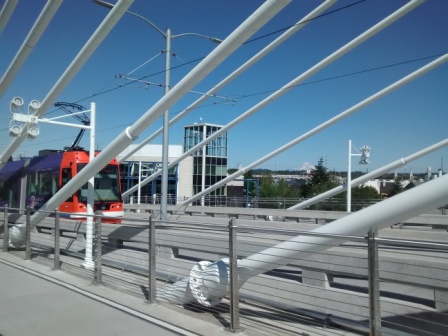
Portland's newest Willamette River bridge opened in 2015, and welcomes pedestrians, cyclists, light rail trains, streetcars, and buses. The cable-stayed design is striking. Views to the north include downtown Portland and beyond, while views to the south include the South Waterfront and Ross Island. To the east Mt. Hood casts its presence over the city.
At the west end of the Tilikum Crossing you will find two new strikingly-designed buildings. Both belong to the riverfront campus of Oregon Health and Sciences University (OHSU), whose main campus looms a couple of miles to the west on "pill hill." The more unusual building, pictured here, hosts the dental school.
Once across the bridge cross the train tracks and head to the left (south) toward the South Waterfront. After crossing under the Ross Island Bridge, which carries a lot of cars and trucks, you will pass by a mixture of new uses (apartment building to the right) and old uses (shipyard to the left). Straight ahead is another OHSU medical building and, in front of it, the lower station of
Portland's Aerial Tram. If you have a bit of time you can take the tram from this station up to Oregon Health and Science University's main campus. A round trip is $4.55 and promises some great aerial views of Portland on the short ride.
When under the tram turn right and cross the street. Ahead you will see this elevator and long staircase leading to the Darlene Hooley Pedestrian Bridge, also known as the
Gibbs Street Pedestrian Bridge. (For more on Darlene Hooley, see
here) The bridge goes over Interstate 5 and is a vital connection between the South Waterfront and the Lair Hill neighborhood to the west. You have the choice of the easy way (elevator) or the hard way (132 stair) up.
Once you get to the top of the bridge, before crossing over the freeway look back at the last remaining vestige of the former industrial South Waterfront area, the Zidell Yards barge construction area.
This picture shows what you would have seen from this spot 30 years ago. Some day this barge construction facility will be gone too, but not yet.
Continue across the pedestrian bridge, which also sees a lot of bike traffic. Above you is the route of the tram. You will notice that, once past the bridge, the tram flies over a residential neighborhood. This fact provoked quite a bit of
opposition in the first years of the 21st century. Most notably, one resident placed a large sign stating "Fuck the Tram" on his roof - after a decent interval the city negotiated the sign's removal.
At the end of the bridge continue one block west on Gibbs to your starting point.