Sunday, September 4, 2016

South Waterfront - SW Portland (and a bit of SE)


Portland's South Waterfront area has seen dramatic changes in the past 20 years. A former waterfront industrial area south of the I-5 Marquam Bridge is now a bustling hub of hipster business and residential activity. The recent opening of the landmark Tilikum Bridge over the Willamette, available to all forms of traffic except motor vehicles, has opened up new vistas and provided new routes for walking. A pedestrian bridge over I-5 from the South Waterfront connecting with the Lair Hill neighborhood to the west has ended an awful choice pedestrians used to have to make between walking a couple miles out of the way or taking their lives into their hands navigating the Ross Island Bridge approaches. This 3.5 mile loop also goes through an interesting historic slice of Portland - the South Auditorium urban renewal district, now a mixture of 1970's modernism and the early 21st century reworking of that modernism. Also featured are the century-old Hawthorne Bridge and the Oregon Museum of Science and Industry. This route is packed with interesting things to see and experience!


The walk begins at the corner of SW Corbett Ave. and SW Gibbs St. in the Lair Hill neighborhood. The walk starts here because, unlike most of the route, street parking is free. There is a two-hour limit during weekday daylight hours, and no limits for the rest of the week. From the intersection turn north toward downtown and follow Corbett as it veers to the left (there is a name change to Grover Street). You will soon see this pedestrian tunnel under Naito Parkway, paralleling the street. The tunnel is well-lighted, and any alternative route would require you to cross busy Naito Parkway at an unsignalized intersection, but still, be alert as you go through the tunnel.

After going through the tunnel Grover Street curves to the right and becomes First Avenue. At the first left turn onto Woods Street. This 1889 Victorian home on the corner has been converted into a triplex condominium, and looks well cared-for.


After one block turn right onto Second Avenue. At the corner, to the right, is the Cedarwood Waldorf School. The school, part of a nationwide network of private schools implementing the teaching philosophy of Rudolph Steiner, is located in a building from 1910, known as the Neighborhood House. The Neighborhood House was a Settlement House, built by the National Council of Jewish Women. Settlement houses served as social welfare organizations in the days prior to government social welfare programs. Lair Hill and South Portland, the route of much of this walk, was the center of Portland's Jewish community in the early 20th century.


Across the street from the Waldorf School is Lair Hill Park. One would think that the Lair Hill neighborhood, and this park, were named after a Mr. Lair, since the site is elevated above the river and downtown. However, the neighborhood is actually named after Mr. William Lair Hill. Among its other attributes the park contains a Carnegie Library, now used for recreation programs.


Continue three blocks on Second Avenue to Meade Street, then turn right. On the corner of Meade and Second is this former church, built in 1900, that is now a single-family residence. While originally a church, for almost a century it was the home to the Kesser Israel Orthodox Jewish congregation, which occupied the building until 2008.


Continue one block on Meade to First Avenue, then turn left. Across the street are two charming Victorian homes from the late 19th century. The remnants of the old South Portland neighborhood such as this make us mourn its loss in a different time, when existing neighborhoods were considered dilapidated and worthy only of demolition, rather than charming and worthy of preservation.


Continue on First Avenue across a signalized intersection at Arthur Street to the first major disrupter of the South Portland neighborhood, the I-405, or Stadium, freeway. Construction began in 1964 and finished when the Fremont Bridge over the Willamette connected to I-5 at its northern end in 1973. The freeway provides a loop from I-5, connecting to the Highway 26 freeway to the west and U.S. 30 to the northwest.


Concurrent with I-405's swath through South Portland the neighborhood was the site of Portland's largest urban renewal effort in the 1960's and 1970's, a 110-acre complete demolition and rebuild of what was known as the South Auditorium District. As you continue north on First Avenue you will see the classic results of mid-20th century urban renewal, "towers in the park." The block on the west side of First Avenue, north of I-405, contains several residential towers built in the 1970's in a classic "international" modernist style.


Continue on First Avenue to Lincoln Street, then turn left, after crossing the street. This street is home to Portland's newest light rail line, the Orange Line from downtown Portland to Milwaukie. Lincoln Street's look has changed quite a bit since the line started a couple of years ago, but the controversy over removal of trees in the center of the street seems to have disappeared.


As you continue along Lincoln Street you will soon come to the Linc, a newer addition to the apartments and condos in South Portland. The Linc, having been built after the turn of the 21st century, is architecturally quite different from the "towers in the park" that were built as part of the South Portland urban renewal project several decades earlier. The Linc is a great example of the maxing out of wood-frame buildings at six stories, based upon generally accepted building codes. Going higher requires steel or concrete construction, which is much more expensive. So central Portland is filling up with six-story apartment buildings, like the Linc, as a result.


After passing the Linc you will see this wide pathway to the right of Lincoln Avenue. It approximates where Third Street used to run before the South Auditorium urban renewal project changed the street pattern forever in this area. Turn right and follow the pathway.


The pathway runs between residential buildings to the right and the backs of Portland State University campus buildings to the left. Eventually to the right you will come across Lovejoy Fountain Park. This centerpiece of the South Auditorium redevelopment project was designed by famous landscape architect Lawrence Halprin.


Continuing north on the pathway, you are headed toward the KOIN center, still several blocks north. Constructed in 1984, the building was the focus of short-lived controversy because it blocked the view of Mount Hood visible for motorists exiting the Vista Ridge Tunnel on the U.S. 26 freeway a couple of miles to the west. The building is named for KOIN-TV, the CBS affiliate in Portland, which has its studios located in the building. The upper floors are taken up by luxury condominiums.


Continue on the pathway to Market Street, and after crossing Market you will be on Third Avenue. To the right is the Keller Auditorium, originally the Civic Auditorium, in this location since 1917, but extensively redone in a bland modernist style in 1966. It hosts opera, ballet, and traveling Broadway musicals, but no longer the Oregon Symphony, which moved to the Arlene Schnitzer Concert Hall (a glorious repurposed old 1920's movie theater) in 1984. But the chief attraction here is to the left - the Ira Keller Fountain, which takes up a whole city block. Opened in 1970, the fountain was also designed by Lawrence Halprin.

Continue on Third Avenue across Clay Street. On your right is the KOIN Tower. Continue another two blocks to Jefferson Street. On your left is Terry Schrunk Plaza, named for the long-time Mayor of Portland from 1957 to 1973. On the far (west) side of the Plaza is the Italian Renaissance-style Portland City Hall, constructed in 1895. Schrunk Plaza is actually owned by the Federal Government, because it covers an underground parking garage built in conjunction with the federal building across Third Avenue to the right. This became an issue in 2011 when Occupy Portland protesters moved into the plaza and were promptly booted out, as opposed to a more tolerant city attitude in the two park square blocks to the north of Schrunk Plaza.

To the right on Third Avenue are three blocks devoted to large government buildings. First is the Edith Green-Wendell Wyatt federal building, constructed in 1975 and given a new more interesting facade in 2009. Green and Wyatt were two long-time Oregon congresspersons from the middle of the 20th century. Next is the Multnomah County Justice Building, which contains among other users the County Jail and the Portland Police Bureau headquarters. It does not include the County Courts, which are in an historic building to the west. Finally, farthest away is the Mark O. Hatfield courthouse, named for Oregon's long-time U.S. Senator and former Governor, opened in 1997. Its tenants include the U.S. District Court for Oregon and Ninth Circuit Court Northwest branch.


At Madison Street turn right and head toward the Willamette River. Straight ahead is the Hawthorne Bridge - you will be crossing over it on the south (right) side. The bridge opened for business in 1910. Fortunately river traffic has declined since then, because the bridge seems to have the least clearance above the river of all the Portland bridges. The extra-wide sidewalk on each side doubles as a bike lane, and is clearly divided between pedestrian and bike use. The bridge gets an incredible amount of bike traffic, over 5,000 bike trips per day - the figure is confirmed by the city's bike counter located on the bridge.


As you walk over the bridge the view to the south includes the massive double-deck Marquam Bridge carrying I-5 freeway traffic (and nothing else), constructed in 1963. Beyond is the Tilikum Bridge (about which more later), which carries everything EXCEPT auto traffic.


As you approach the east bank of the Willamette you will see a ramp down from the bridge to the right. Take the ramp, which is shared with bicycle traffic. The trail along the east side is the official beginning of the 40+ mile long Springwater Corridor, but is more popularly known as the Eastbank Esplanade, which officially runs only north from the Hawthorne Bridge along the east side of the Willamette River.


The pathway along the east side of the Willamette is marred by the freeway noise from I-5 above. A fair number of homeless people frequent the path. However it also hosts a large slice of the rest of Portland humanity and is well-used. After walking a bit you will see this dock extending into the river. On a sunny summer day it will be filled with sunbathers and river swimmers. Any time of year it's worth a walk out onto the dock to enjoy the views of the river and its bridges and downtown Portland on the other side.


Continuing along the pathway you will soon come to a significant Portland institution, the Oregon Museum of Science and Industry, which located here on the site of an old electric generating plant in 1992. Part of the museum lies in the river to the right - the USS Blueback, which was the last non-nuclear American submarine warship.


Continue on the pathway past OMSI, and you will veer to the left to get to the "onramp for the Tilikum Crossing Bridge.


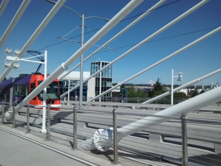
Portland's newest Willamette River bridge opened in 2015, and welcomes pedestrians, cyclists, light rail trains, streetcars, and buses. The cable-stayed design is striking. Views to the north include downtown Portland and beyond, while views to the south include the South Waterfront and Ross Island. To the east Mt. Hood casts its presence over the city.


At the west end of the Tilikum Crossing you will find two new strikingly-designed buildings. Both belong to the riverfront campus of Oregon Health and Sciences University (OHSU), whose main campus looms a couple of miles to the west on "pill hill." The more unusual building, pictured here, hosts the dental school.


Once across the bridge cross the train tracks and head to the left (south) toward the South Waterfront. After crossing under the Ross Island Bridge, which carries a lot of cars and trucks, you will pass by a mixture of new uses (apartment building to the right) and old uses (shipyard to the left). Straight ahead is another OHSU medical building and, in front of it, the lower station of Portland's Aerial Tram. If you have a bit of time you can take the tram from this station up to Oregon Health and Science University's main campus. A round trip is $4.55 and promises some great aerial views of Portland on the short ride.


When under the tram turn right and cross the street. Ahead you will see this elevator and long staircase leading to the Darlene Hooley Pedestrian Bridge, also known as the Gibbs Street Pedestrian Bridge. (For more on Darlene Hooley, see here) The bridge goes over Interstate 5 and is a vital connection between the South Waterfront and the Lair Hill neighborhood to the west. You have the choice of the easy way (elevator) or the hard way (132 stair) up.


Once you get to the top of the bridge, before crossing over the freeway look back at the last remaining vestige of the former industrial South Waterfront area, the Zidell Yards barge construction area. This picture shows what you would have seen from this spot 30 years ago. Some day this barge construction facility will be gone too, but not yet.


Continue across the pedestrian bridge, which also sees a lot of bike traffic. Above you is the route of the tram. You will notice that, once past the bridge, the tram flies over a residential neighborhood. This fact provoked quite a bit of opposition in the first years of the 21st century. Most notably, one resident placed a large sign stating "Fuck the Tram" on his roof - after a decent interval the city negotiated the sign's removal.


At the end of the bridge continue one block west on Gibbs to your starting point.

Monday, June 27, 2016

Oceanside

One of the most spectacular spots on the Oregon Coast, a coastline full of spectacular spots, is the small village of Oceanside, almost directly west of Tillamook. This small town is built for the most part on the side of a hill rising steeply from the Pacific and overlooking the Three Arch Rocks National Wildlife Preserve. This 2 mile walk will take you up and back down the steep hill on which the town is perched and then along the beach itself, including an interesting surprise at the end.


Start the walk at the Oceanside Beach State Recreation Site parking lot. Don't go down to the beach just yet - instead you will be going up this hillside of houses for some spectacular views back toward the ocean and the rocks. The Recreation Site is for day use only. The land was donated to the state by very public-minded local property owners.

Start up the hill on Maxwell Mountain Road. Where the road turns to the left it becomes a one-way street, for what will soon become an obvious reason. The warning sign pictured is also very good advice.

The road is narrow and unpaved, but fortunately traffic is very light and very slow. The views are spectacular. The rocks you see offshore are the Three Arch Rocks National Wildlife Refuge, established in 1907 as the first national wildlife refuge on the Pacific coast. The story of the establishment of the refuge can be found here.

As you continue up the hill you will also see some spectacular examples of hillside architecture, such as this house. All with great views, and hopefully all with solid geotechnical foundations!


The road makes a hairpin turn to the right above Maxwell Point - once past the turn take the road that goes more to the left, farther up the hill. On Maxwell Point is an abandoned (as of 2016) hotel. Until 1968 this spectacular spot was home to the Viewpoint Inn. It was replaced by the current buildings, once known as the House on the Hill and then the Clifftop Motel. It's unclear why the motel closed - there is an interesting court case involving a same-sex couple, artificial insemination, and parental rights, but the two were managers of the motel, not owners. It is hard to imagine failing in the motel business at this particular site.
Continuing up the hill on Maxwell Mountain Road the street remains narrow and unpaved, the sparse traffic is slow, the houses are precariously perched, and the views are fabulous.

Continue up and up. Eventually you will get to this viewpoint along the road, also the location where Maxwell Mountain Road makes another hairpin turn up the hill. You, however, will turn right onto Cedar Street and start heading down the hill along the roadway.

Cedar Street has plenty of trees along its sides as you head down the hill. At the intersection of Cedar and Chinook Streets is this unusual home, trying to take advantage of the view opportunities above the trees toward the ocean.


Continue straight, as the street you are on is now Chinook Avenue, continuing on a more gentle slope down the hill. On the right is the Oceanside Chapel, the only religious institution in town. The non-denominational congregation meets for worship on Saturday evenings. The chapel also serves as a designated emergency gathering place after the big earthquake and tsunami some day.

At Lilac Street turn right, and after one block turn left onto Sunset Avenue. Walk four blocks on Sunset Avenue to Cape Meares Loop, a major street. Turn right here and go one block to Pacific Avenue, where you will turn right. Pacific Avenue is the "main street" of Oceanside, with a post office, a few shops, and several restaurants.

Eventually you will get back to your starting point at the Oceanside Beach State Wayside, but don't finish this walk quite yet!. Go from the parking lot down to the beach and turn right. Bring along a flashlight if you can.

Oceanside beach is one of the most scenic on the Oregon Coast, and that is hearty praise! As you walk along the sand (your precise location will depend upon the tide) enjoy the views of the Three Arch Rocks and the bird life that is often nearby on the sands.


Ahead is Maxwell Point, and this tunnel entrance. There's a sign at the entrance warning of rock falls, but go ahead and peer in. You'll see light at the end of the tunnel - this is definitely no dead end! The Maxell Point tunnel was built in the early 20th century and is currently passable. But the floor of the tunnel is quite rocky in its middle, which is why you should have the flashlight along.


And this is the view from the tunnel's north portal. It is known as Lost Boy Beach, and if you want to extend your walk, continue north until you run out of beach near Cape Meares. And then head back through the tunnel, back along Oceanside Beach, to your starting point at the Wayside.

Friday, May 13, 2016

Salem Religious Institutions

Salem has a number of distinctive religious buildings in its central area. This 4.2 mile long walk will take you by a number of them, as you meander through central Salem. All but two of the buildings along the route are Christian in nature, the exceptions being a Buddhist temple and a Bahai worship place. The walk also traipses through Willamette University, the downtown commercial district, and the State Capitol. While long, the route is level.


The walk begins at the corner of 17th Street and Chemeketa Street NE. On the corner is the Chemeketa Street Evangelical Church building, which has been converted to a private residence. The church was originally built in 1894. While it is not individually on the National Register of Historic Places, the entire Court-Chemeketa neighborhood in this area is on the National Register. The original church vacated the building in 1929, and later it was used by Mennonites and then the LDS Church ("Mormons") until conversion to a private residence some time before 1987. The original Evangelical Church that inhabited the building was probably an ethnic German congregation, espousing the Calvinist strain of German Protestantism (in contrast to Lutherans).
Go south on 17th Street. In one block, at the corner of Court and 17th, is the Court Street Christian Church. While this building was constructed in 1949, the church has been located on this site since 1913, started as an east Salem "extension" of the First Christian Church in downtown Salem (visited later on this tour). Looking at the church's website, it appears to be non-denominational, professing no connection to any larger or national church organization. The church's theology states that the Bible is the only authority for its faith, but does not explicitly state that the Bible is inerrant.

Continue on 17th Street to its intersection with State Street. Turn left and go two blocks on State Street. At the corner of 18th and State is the State Street Church of God, which has only this sparse Facebook page for its online presence. More information about the building's history is available here. The church building was constructed a few years after 1900 for a predecessor of the Evangelical Lutheran Church, a "mainline" Protestant denomination (see discussion for St. Mark Lutheran Church later on this walk). After a stint as a Baptist church the present congregation arrived in 1976. It appears to be a non-denominational church, which means it has no affiliation with a larger group of churches.

At 19th Street turn right and go one block to Ferry Street. On the corner of 19th and Ferry is the Korean Church of Salem. The church has a Facebook page without much content. The Korean Church of Salem is a Presbyterian congregation. The building was originally constructed in 1926 by a Congregationalist congregation which closed its doors and sold the building to its current occupants in 2005.

Turn right on Ferry Street and then turn left onto 18th. Go two blocks on 18th to Mill Street, then turn right and go three blocks on Mill to 15th Street - carefully cross busy 17th Street. At the corner of 15th and Mill is the Mia Chung Buddhist Temple, located in this attractive red building. The temple does not have a website - in fact, it appears to have no internet presence of any kind.


Continue on Mill Street to its terminus at 12th Street. Use the pedestrian crosswalk to carefully cross traffic, and then head right on 12th Street. After you pass the parking lot on your left turn left into the Willamette University campus. Turn right between the first two buildings, and then left at the first opportunity between buildings. Continue to the large green area known as the Quad. Go around the Quad to the right and stop at the second building on the right. This is Waller Hall, the oldest building on campus (dating from 1867). Among other campus offices it is the home of Cone Chapel, the school's religious facility.

If you visit during weekdays you can go into the chapel itself. In its current form it was consecrated in 1989. It features a stately pipe organ in the front and a dozen large stained glass windows. While Willamette University was founded in 1842 by Methodist missionaries the school has long been unaffiliated with any religious institutions.


After leaving Waller Hall continue north toward the State Capitol. At State Street turn left and head down the street. At the intersection of State and Cottage Streets, to the left,  is a Baha'i Faith Center. The Baha'i Faith was founded in 19th century Iran, and asserts a synthesis of past prophets of many world religions into a new monotheistic religion of world peace and unity. There are about 5 million adherents worldwide. The largest number used to be in Iran, but the Islamic regime under Ayatollah Khomeini and his successors has worked to ruthlessly extirpate the faith from that county since 1980.

Continue straight ahead on State Street for another block to Church Street. The street may be named for this structure, the First Methodist Church of Salem on the corner of State and Church Streets, originally built in 1878. Its spire is taller than every other structure in the city other than the State Capitol.  The original spire had to be replaced in 1984, but the new spire is an identical match. The United Methodist Church has 7.2 million adherents in the U.S., making it the third largest national church (behind Roman Catholicism and the Southern Baptists). This "mainline" Protestant church has its origins in the preachings and teachings of legendary 18th century evangelist John Wesley.

Turn right onto Church Street and proceed two blocks to Chemeketa Street, where you will turn left. After three blocks on Chemeketa turn right onto Commercial Street. In the first block, on the left, is the Union Gospel Mission. Founded in 1953, it serves the homeless while trying to convert them to Christianity, or at least have them become receptive to Christian teachings. There are many such Christian homeless shelters and providers of services to the homeless throughout the U.S. - the largest of these is the Salvation Army.

After two blocks on Commercial Street turn right onto Marion Street. After one block, on the corner of Marion and Liberty Streets, is the Salem First Baptist Church. A short history of the church is found here - while the church has been on this site since 1868, the current building was constructed in 1951. First Baptist does not make any mention of a national affiliation on its website, but it appears to be part of the Conservative Baptist Association, a loose group of churches that split from the more "liberal" Northern Baptist Convention in the middle of the last century. The history of formations, splits, and unions of groups of Baptist churches in this nation is much too complicated for any explanation here. National Baptist church organizations are often very loosely organized, and the particular theology of individual Baptist churches in the same grouping may vary widely. The Baptist faith is differentiated from other versions of Christianity by belief that the act of baptism - committing oneself to the Christian faith by complete immersion in water, is only possible for consenting adults (as opposed to the practice of other Christians, most notably Roman Catholics, of baptizing infants).

Turn left onto Liberty Street and after one block turn right at Union Street. After two blocks on Union turn left onto Church Street and walk north. At 675 Church St. NE is this beautiful old federal-style home. It is the Endicott House, built in 1910. and now converted into offices.


Continue north on Church Street. You will soon reach this bridge in the road that crosses Mill Creek. This waterway, augmented by a diversion from the Santiam River, meanders around the central Salem area, occasionally flooding homes and other buildings along its banks.

Continue on Church Street to "D" Street, then turn right. After one block, at the corner of Cottage and "D",  is the Evergreen Presbyterian Church. This congregation is a member of the Presbyterian Church in America (PCA). The PCA split from the mainstream Presbyterian Church U.S.A. in the 1970's as a conservative reaction to the increasing liberalism of the national Presbyterian church, disagreeing with among other theological innovations the ordination of women. However the building, constructed in 1928 in a neo-Gothic style, was originally the Bethel Baptist Church, and has only been occupied by the current Presybterian congregation since 2008.
Turn right onto Cottage Street and go back south. After one long block you will reach Union Street - proceed another block to Marion Street. Between Union and Marion on your left is the Old Garfield School Building. Constructed in 1909, it served as an elementary school until 1973. It has now been repurposed as office space, and is on the National Register of Historic Places.

Opposite the Old Garfield School Building, on your right, is the Salem First Christian Church. The church is part of the Disciples of Christ national church. The church requires a belief in Jesus Christ as the Son of God, but encourages its individual churches and members to find their own way in Christianity and not follow any additional established doctrine. The church's national membership has declined steeply from 2 million in the 1950's to 650,000 today. Three Presidents, James Garfield, Lyndon Johnson, and Ronald Reagan, were Disciples of Christ at some point in their lives. This brick building that is home to the congregation was built in 1951, although the congregation was established in Salem way back in 1867.

Turn left onto Marion Street. On your right is the First Congregational United Church of Christ. The church's website describes itself as a "long established, theologically liberal, open and affirming, just peace congregation." The United Church of Christ is the most theologically and politically progressive of mainline Protestant churches in the United States, which is interesting, since Congregationalism has its roots in the austere Puritan churches of 17th century Massachusetts. The history of First Congregational in Salem goes back to 1852 - the current building was dedicated in 1941.

The next church is adjacent to the First Congregational Church, at the corner of Marion and Winter Streets, on your right - St. Mark Lutheran Church. This "American" Lutheran Church (with services in English instead of German) was formed in 1927, and originally used the "Old Presbyterian Church" building a couple of blocks away on Church Street. In 1958 the church dedicated this building and the old church, originally built in 1894, was demolished. St. Mark is a member of the Evangelical Lutheran Church of America (ELCA), which is a mainline Protestant denomination. This branch of Lutheranism is in "full communion" with the national Episcopal, Methodist, Reformed, Presbyterian, United Church of Christ, and Moravian Churches, which means that these churches welcome members of sister churches in services. including at communion, recognize ordained ministers of sister churches, and coordinate and worship together in other ways that are described well in this ELCA webpage.

Notably, "full communion" among American churches does not include the Roman Catholic Church in America. Which brings us to the next church building. At Winter Street turn right and go two blocks to Chemeketa -  on the right is St. Joseph Catholic Church. While a Roman Catholic church building has been present on this block since 1864 the current building was completed in 1957, apparently with some local controversy over the height of the bell tower. Behind the church building is St. Joseph's Elementary School.


On the opposite corner of Winter and Chemeketa, on the right, is First Presbyterian Church, built in 1928. Amazingly, this substantial church building was moved to this location. The church was originally at the northeast corner of Winter and Chemeketa Streets. In 1958 it was moved diagonally across the Chemeketa/Winter intersection to its current location, to make room for the State's Bureau of Labor and Industries building. First Presbyterian is a member of the Presbyterian Church USA, a mainline Protestant denomination. Presbyterianism has its roots in the Scottish Reformation of the 16th century, whose leader was John Knox, and is based upon rejection of the rule by bishops and their replacement as leaders by governing boards of lay elders, or presbyters.

Continue one block further on Winter and then turn left onto Court Street. Stay on the left side of the street as you pass the State Capitol on your right, and continue several blocks, past the 12th Street railroad tracks, to the corner of 14th and Court. On your right is St. John Lutheran church. While the building looks older, it was constructed in 1953. St. John is a member of the Missouri Synod branch of Lutheranism, which dates back to a conservative reaction to increasingly "reformed" Lutheranism in early 19th century Germany, and was founded in the United States in 1847. The Missouri Synod Lutherans remain more conservative than the larger, "mainstream"  Evangelical Lutheran Church of America, and are not in full communion with other mainline Protestant faiths.

Continue on Court Street to 15th Street, then turn left. After one short block turn right onto Chemeketa Street, where in two blocks you will be back at your starting point.

About Me

Blogs about biking and walking in the Pacific Northwest