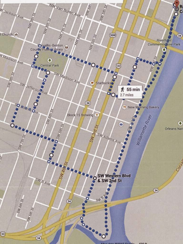
There are two major university towns in Oregon, and we can't ignore lovely Corvallis for much longer. Home to Oregon State University, the city looks like a nice place to live, and it is certainly a nice place to visit. Most visitors probably go to the campus, but Corvallis' central area is worthy of exploration too. This walk will take you through downtown, by some beautiful historic homes, and along the city's Willamette River pathway. The walk is 2.7 miles in length, on flat terrain.
The walk starts at the north end of
Riverfront Commemorative Park, which features a trail along much of the city's Willamette River frontage. There are parking areas near the intersection of First Street and Tyler Avenue. Navigating the central part of Corvallis is easy if you know the chronological order of early U.S. Presidents (but skipping John Quincy Adams, who shares the same last name as his father, the 2nd President, and whose inclusion into a similar street name system in Oregon City seems awkward).
Head south along the Riverfront trail. Soon you will see these two bridges over the Willamette River to the left. The first is the unexceptional Harrison Street bridge, which carries westbound traffic into Corvallis. The second is the Van
Buren Street bridge, which carries eastbound traffic out of Corvallis. It was built in 1913 and is the third oldest existing bridge crossing of the Willamette. It replaced a ferry which operated on this site starting in 1860. The bridge has a swing span, used in its early years to allow the passage of riverboat traffic. However the last opening of the bridge swing span occurred in 1960. Regular river commerce requiring the bridge to swing open had ceased by the late 1920's. There have been studies regarding the replacement of this bridge and its use for non-vehicular traffic or its demolition, but for now it remains a vital traffic artery over the river.
Continuing on the riverfront walkway, three blocks south of the Van Buren Bridge, to the right, is the home of
Flat Tail Brewing, one of several microbreweries in Corvallis.
Continue along the riverfront walkway. The walk has nice views of Corvallis' Willamette River frontage. The Willamette saw a lot of steamboat traffic in the late 19th century after the 1873 construction of the Willamette Falls locks in Oregon City downstream. But the railroads' advance into the Willamette Valley provided tough competition for the steamboats, and the advent of paved roads in the early 20th century killed off commercial river traffic entirely. Across the river from Corvallis was the pioneer town of Orleans, which was washed away by the
Great Flood of 1862 and never rebuilt.
There are several new multi-story buildings along the riverfront, and this 7-story building at Washington Street,
Renaissance on the Riverfront, is the tallest. It has two floors of commercial space topped by five additional floors of condos.
Continuing along the riverfront path, follow the pathway under the Highway 34 bridge. This is a route that, after crossing the Willamette, bypasses downtown Corvallis on its way to the Oregon Coast to the west.
Once under the bridge follow the trail through the natural area along the Willamette River and then to the right along the mouth of the Marys River which joins the Willamette here. The Marys River arises from the west in the Coast Range where its source is near the tallest mountain on the Coast Range, Mary's Peak, a little over 4,000 feet in elevation.
As the trail continues looping to the right you will once again cross under the Highway 34 bridge, past this skate park. Noisy skate parks around the state seem to often be located in areas already noisy, such as under state highway bridges.
Continue past the skate park straight ahead onto Second Street, and then head north for one block. But before reaching Second Street and to the right you will see this striking sculpture of a bird. It is one of
many such sculptures along the Corvallis riverfront and throughout downtown.
After proceeding one block on Second Street turn left onto Western Avenue. Cross busy Third and Fourth Streets at the signal light. After crossing Fourth Street you will be entering the city's
Avery-Helm Historic District. The district, established in 2000, is clearly an attempt to revitalize a formerly neglected part of town, and it holds many interesting historic residences. At Fifth Street turn right. While many of the old houses remaining in pre-World War II historic neighborhoods are much larger, it is interesting to see a smaller, less architecturally ornate home such as this one on the right side of Fifth Street, built in 1905, because in older historic neighborhoods many of these smaller houses have not survived over the years.
After one block on Fifth Street turn left onto Washington Avenue. After one block you will cross Sixth Street, which contains the railroad tracks of the Portland and Western Railway.
This book, which may be in your local library, will provide historical pictures and the history of this and other former Southern Pacific lines in Oregon. This line also has the distinction of being a small part of what was once a
grandiose scheme for a transcontinental railway from Newport on the Oregon Coast all the way to Chicago! It still goes to Toledo on Yaquina Bay, near Newport, but the railroad only got as far as Idanha on its way to the Santiam Pass near Sisters, Oregon before the dream was squashed by financial realities.
Continue one block on Washington to Seventh Street. On your left is the Willamette Valley and Coast Railway
freight depot, originally built in 1887, and moved twice before landing on this site in 1927. It is the oldest two-story wood-frame railroad depot in Oregon. The building is on the National Register of Historic Places.
Continue one block further on Washington Avenue to Eighth Street. On the left are two more structures on the National Register of Historic Places, the Oregon State University Poultry House and Incubator House. Both buildings were constructed on other parts of the campus in the early 20th century, and the story of how they were found, moved to this site, and refurbished, is
quite interesting. Note that you are now on the edge of the Oregon State University campus - a large newer dormitory building is in the background of this picture. The campus will be the subject of another walking tour.
At Eighth Street turn right. After one block turn right again onto Adams Avenue. Go forward one block. At the corner of Adams and Seventh is the
Whiteside House, built in 1927, on the National Register of Historic Places. The Whiteside House is thought to be the only example in Corvallis of a residential architectural style called the
airplane bungalow, so named because the pop-up single-room second story on these homes supposedly resembled the cockpit of a 1920's airplane.
Turn left onto Seventh and go two blocks to Madison Avenue. On your left is the
Corvallis Arts Center, which has been in this location since 1961. However, the building, constructed in a Carpenter Gothic style, was built in 1889 as the Good Samaritan Episcopal Church. It is on the National Register of Historic Places.
To the right at the intersection of 7th and Madison is the George R. Farra House, a mansion built in 1903. It is also on the National Register of Historic Places. Both the Farra Residence and the Corvallis Arts Center front onto Corvallis Central Park, located on the other side of the street.
Next to the Farra House on the south side of Madison is the
First Christian Church of Corvallis, a member of the National
Disciples of Christ denomination. The building was completed in 1925 in a neo-Classical architectural style.
Turn left on Madison Avenue to go around Central Park. Next to the Arts Center is this building, now a mortuary, that was constructed in 1917 as the Corvallis First Congregational Church. This neo-Classical structure is also on the National Register of Historic Places.
At Eighth Street turn right and continue around the edge of the park. To your left is the Corvallis
First Presbyterian Church. The sanctuary was constructed in 1910 and the educational hall was finished in 1928.
Turn right again on Monroe and continue along the edge of Central Park. The 3.5 acre square is a gathering spot for band concerts at its gazebo.
On the left side of Monroe, across from the park, is the Corvallis-Benton County Public Library. This large building was originally designed by noted Portland architect Pietro Belluschi in 1932. It had extensive additions in 1965 and 1992.
Continue on Monroe Avenue across Sixth Street and the railroad tracks again. Continue to Fifth Street. On the left is the Benton County Courthouse, on the National Register of Historic Places. It was constructed in 1889. Its architectural style is described as Italianate. It was extensively remodeled in 1976 to serve courthouse needs in the modern era.
Continue to Fourth Street, which is part of a one-way couplet with Third Street that handles State Highway 99W through traffic. On the right corner is the Benton Hotel, built in 1925. This building, also on the National Register of Historic Places, has been converted to shops on the first floor and apartments above. By the way, Benton County was named for
this historic pre-civil war American politician.
Continue on Monroe to Third Street, then turn right. After one block turn left onto Madison Avenue, and then after one block on Madison turn left onto Second Street. You are now in the heart of old downtown Corvallis. The street sculptures continue throughout downtown, most notably several of these items. I have no idea what they are supposed to represent.
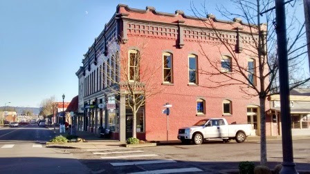
At the corner of Madison and Second is the Corvallis Hotel, another historic lodging structure. This brick building was finished in 1927.
Continue north on Second Street. On your right is the
Majestic Theatre. This venue, constructed in 1913 as a vaudeville house, now hosts local theater productions and musical events.
Next to the Majestic Theater, at the corner of Second and Monroe, is the Julian Hotel, originally constructed in 1893 with fireproof brick construction. It now
provides apartments for low-income renters.
At Jackson Street turn right toward the riverfront. On the right is the home of
Sky High Brewing, the second of the downtown Corvallis micro-breweries. The third brewery,
Block 15 Brewing, is located at the corner of Third and Jefferson only one block from the walk pathway (if you want to sample local beers at all three spots).
After reaching the riverfront turn left and head back up the riverfront path for three blocks to your starting point at First Street and Tyler Avenue.