Wednesday, April 8, 2015

Corvallis - downtown


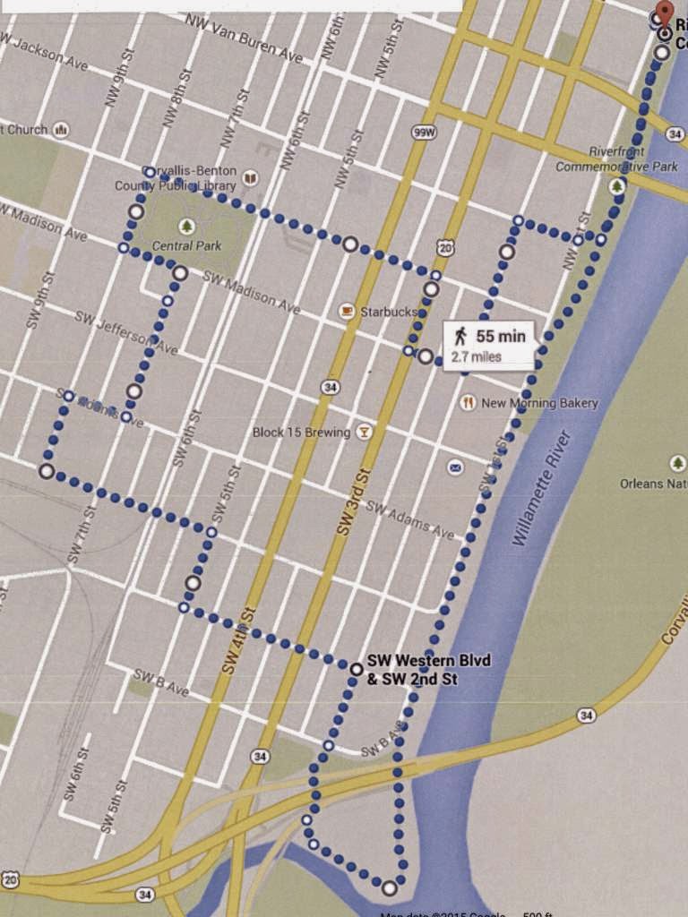
There are two major university towns in Oregon, and we can't ignore lovely Corvallis for much longer. Home to Oregon State University, the city looks like a nice place to live, and it is certainly a nice place to visit. Most visitors probably go to the campus, but Corvallis' central area is worthy of exploration too. This walk will take you through downtown, by some beautiful historic homes, and along the city's Willamette River pathway. The walk is 2.7 miles in length, on flat terrain.


The walk starts at the north end of Riverfront Commemorative Park, which features a trail along much of the city's Willamette River frontage. There are parking areas near the intersection of First Street and Tyler Avenue. Navigating the central part of Corvallis is easy if you know the chronological order of early U.S. Presidents (but skipping John Quincy Adams, who shares the same last name as his father, the 2nd President, and whose inclusion into a similar street name system in Oregon City seems awkward).

Head south along the Riverfront trail. Soon you will see these two bridges over the Willamette River to the left. The first is the unexceptional Harrison Street bridge, which carries westbound traffic into Corvallis. The second is the Van Buren Street bridge, which carries eastbound traffic out of Corvallis. It was built in 1913 and is the third oldest existing bridge crossing of the Willamette. It replaced a ferry which operated on this site starting in 1860. The bridge has a swing span, used in its early years to allow the passage of riverboat traffic. However the last opening of the bridge swing span occurred in 1960. Regular river commerce requiring the bridge to swing open had ceased by the late 1920's. There have been studies regarding the replacement of this bridge and its use for non-vehicular traffic or its demolition, but for now it remains a vital traffic artery over the river.

Continuing on the riverfront walkway, three blocks south of the Van Buren Bridge, to the right, is the home of Flat Tail Brewing, one of several microbreweries in Corvallis.


Continue along the riverfront walkway. The walk has nice views of Corvallis' Willamette River frontage. The Willamette saw a lot of steamboat traffic in the late 19th century after the 1873 construction of the Willamette Falls locks in Oregon City downstream. But the railroads' advance into the Willamette Valley provided tough competition for the steamboats, and the advent of paved roads in the early 20th century killed off commercial river traffic entirely. Across the river from Corvallis was the pioneer town of Orleans, which was washed away by the Great Flood of 1862 and never rebuilt.

There are several new multi-story buildings along the riverfront, and this 7-story building at Washington Street, Renaissance on the Riverfront, is the tallest. It has two floors of commercial space topped by five additional floors of condos.


Continuing along the riverfront path, follow the pathway under the Highway 34 bridge. This is a route that, after crossing the Willamette, bypasses downtown Corvallis on its way to the Oregon Coast to the west.


Once under the bridge follow the trail through the natural area along the Willamette River and then to the right along the mouth of the Marys River which joins the Willamette here. The Marys River arises from the west in the Coast Range where its source is near the tallest mountain on the Coast Range, Mary's Peak, a little over 4,000 feet in elevation.


As the trail continues looping to the right you will once again cross under the Highway 34 bridge, past this skate park. Noisy skate parks around the state seem to often be located in areas already noisy, such as under state highway bridges.


Continue past the skate park straight ahead onto Second Street, and then head north for one block. But before reaching Second Street and to the right you will see this striking sculpture of a bird. It is one of many such sculptures along the Corvallis riverfront and throughout downtown.


After proceeding one block on Second Street turn left onto Western Avenue. Cross busy Third and Fourth Streets at the signal light. After crossing Fourth Street you will be entering the city's Avery-Helm Historic District. The district, established in 2000, is clearly an attempt to revitalize a formerly neglected part of town, and it holds many interesting historic residences. At Fifth Street turn right. While many of the old houses remaining in pre-World War II historic neighborhoods are much larger, it is interesting to see a smaller, less architecturally ornate home such as this one on the right side of Fifth Street, built in 1905, because in older historic neighborhoods many of these smaller houses have not survived over the years.


After one block on Fifth Street turn left onto Washington Avenue. After one block you will cross Sixth Street, which contains the railroad tracks of the Portland and Western Railway. This book, which may be in your local library, will provide historical pictures and the history of this and other former Southern Pacific lines in Oregon. This line also has the distinction of being a small part of what was once a grandiose scheme for a transcontinental railway from Newport on the Oregon Coast all the way to Chicago! It still goes to Toledo on Yaquina Bay, near Newport, but the railroad only got as far as Idanha on its way to the Santiam Pass near Sisters, Oregon before the dream was squashed by financial realities.

Continue one block on Washington to Seventh Street. On your left is the Willamette Valley and Coast Railway freight depot, originally built in 1887, and moved twice before landing on this site in 1927. It is the oldest two-story wood-frame railroad depot in Oregon. The building is on the National Register of Historic Places.


Continue one block further on Washington Avenue to Eighth Street. On the left are two more structures on the National Register of Historic Places, the Oregon State University Poultry House and Incubator House. Both buildings were constructed on other parts of the campus in the early 20th century, and the story of how they were found, moved to this site, and refurbished, is quite interesting. Note that you are now on the edge of the Oregon State University campus - a large newer dormitory building is in the background of this picture. The campus will be the subject of another walking tour.

At Eighth Street turn right. After one block turn right again onto Adams Avenue. Go forward one block. At the corner of Adams and Seventh is the Whiteside House, built in 1927, on the National Register of Historic Places. The Whiteside House is thought to be the only example in Corvallis of a residential architectural style called the airplane bungalow, so named because the pop-up single-room second story on these homes supposedly resembled the cockpit of a 1920's airplane.


Turn left onto Seventh and go two blocks to Madison Avenue. On your left is the Corvallis Arts Center, which has been in this location since 1961. However, the building, constructed in a Carpenter Gothic style, was built in 1889 as the Good Samaritan Episcopal Church. It is on the National Register of Historic Places.


To the right at the intersection of 7th and Madison is the George R. Farra House, a mansion built in 1903. It is also on the National Register of Historic Places. Both the Farra Residence and the Corvallis Arts Center front onto Corvallis Central Park, located on the other side of the street.


Next to the Farra House on the south side of Madison is the First Christian Church of Corvallis, a member of the National Disciples of Christ denomination. The building was completed in 1925 in a neo-Classical architectural style.


Turn left on Madison Avenue to go around Central Park. Next to the Arts Center is this building, now a mortuary, that was constructed in 1917 as the Corvallis First Congregational Church. This neo-Classical structure is also on the National Register of Historic Places.


At Eighth Street turn right and continue around the edge of the park. To your left is the Corvallis First Presbyterian Church. The sanctuary was constructed in 1910 and the educational hall was finished in 1928.


Turn right again on Monroe and continue along the edge of Central Park. The 3.5 acre square is a gathering spot for band concerts at its gazebo.


On the left side of Monroe, across from the park, is the Corvallis-Benton County Public Library. This large building was originally designed by noted Portland architect Pietro Belluschi in 1932. It had extensive additions in 1965 and 1992.


Continue on Monroe Avenue across Sixth Street and the railroad tracks again. Continue to Fifth Street. On the left is the Benton County Courthouse, on the National Register of Historic Places. It was constructed in 1889. Its architectural style is described as Italianate. It was extensively remodeled in 1976 to serve courthouse needs in the modern era.


Continue to Fourth Street, which is part of a one-way couplet with Third Street that handles State Highway 99W through traffic. On the right corner is the Benton Hotel, built in 1925. This building, also on the National Register of Historic Places, has been converted to shops on the first floor and apartments above. By the way, Benton County was named for this historic pre-civil war American politician.


Continue on Monroe to Third Street, then turn right. After one block turn left onto Madison Avenue, and then after one block on Madison turn left onto Second Street. You are now in the heart of old downtown Corvallis. The street sculptures continue throughout downtown, most notably several of these items. I have no idea what they are supposed to represent.


At the corner of Madison and Second is the Corvallis Hotel, another historic lodging structure. This brick building was finished in 1927.

Continue north on Second Street. On your right is the Majestic Theatre. This venue, constructed in 1913 as a vaudeville house, now hosts local theater productions and musical events.


Next to the Majestic Theater, at the corner of Second and Monroe, is the Julian Hotel, originally constructed in 1893 with fireproof brick construction. It now provides apartments for low-income renters.


At Jackson Street turn right toward the riverfront. On the right is the home of Sky High Brewing, the second of the downtown Corvallis micro-breweries. The third brewery, Block 15 Brewing, is located at the corner of Third and Jefferson only one block from the walk pathway (if you want to sample local beers at all three spots).


After reaching the riverfront turn left and head back up the riverfront path for three blocks to your starting point at First Street and Tyler Avenue.

Friday, February 27, 2015

Mt. Tabor

Portland's Mt. Tabor neighborhood is named for the extinct volcanic  cinder cone that rises 636 feet in elevation in its middle. The "mountain" itself is a park (with a large city reservoir system included), but is surrounded by a residential community. The western portion of the Mt. Tabor neighborhood, in the direction of downtown Portland, includes lots of grand old homes and historic structures to enjoy looking at. This walk, 2.8 miles long, will take you by many of these architectural treasures, and it will also include a journey to the lower reaches of the Mt. Tabor Park. The route includes moderate ups and downs, especially in the portion within the park.


This walk begins at the Mt. Tabor Presbyterian Church, located at the intersection of SE Belmont Street and SE 55th Avenue. While the church has been located at this site since 1892, this building was constructed in 1910. The ever-popular (at the time) bell tower designed to look like a romanticized medieval castle turret dominates the structure. The church has made great efforts in recent years to reach out to the community in different ways, efforts that are chronicled on the church's website.

Cross Belmont Street to the east side of SE 55th Avenue. At the corner is the Irvington Masonic Lodge building, which according to a plaque in the front was constructed in 1952 - it looks much older. There is no sign of continued masonic use of the building, which is not surprising given the steep decline in Masonic membership in the U.S. over the past several decades. Although no signs indicate it, the building now houses the Mt. Hood Model Engineers Club, dedicated to the creation and maintenance of model trains.


From the Masonic Lodge building continue south on 55th Avenue. This street contains a number of fine old homes. This one on the right between Taylor and Salmon Streets, built in 1900, is located on a lot almost one acre in size, and now houses the Vedanta Society of Portland. Vedanta philosophy claims to be the foundation of Hinduism. The leaders of the society are known as Swamis. The current leader in Portland is Swami Shantarupananda.

Continuing along SE 55th Avenue, on the left between Salmon and Madison is the Samuel Cobb House, a large craftsman-style home constructed in 1911. It is on the National Register of Historic Places. Samuel Cobb was a prosperous Portland sawmill owner who designed and built the house himself. Among the beautiful craftsman interior finishes are seven fireplaces.

The next block on the left, between Madison and Hawthorne, is home to the Western Theological Seminary Portland branch. The seminary describes itself as "a theologically conservative graduate school that promotes true innovation and humility in ministry practice. The Bible is God's inerrant Word and we set it at the center of our curriculum in the belief that faith and practice must be driven by principled interpretation and integration of the scriptures." However the house itself is located on the site of the first home in the area, constructed by pioneer Peter Prettyman in 1846, at the head of Hawthorne Street. The current house was constructed by Philip Buehner in the first decade of the 20th century. A history of the site and the house can be found here

At Hawthorne Street, after passing the Seminary building, turn left. Go five blocks through the neighborhood to 60th Avenue, where you should carefully cross this busy street. turn right, and after a few hundred feet you will see this stairway on the left. Take it up to the turret above, which you will soon see is part of the Mt. Tabor water reservoir.


At the top of the steps you will see the main reservoir. Before turning right to go around the reservoir, note this sign. Perhaps what this guy did doesn't qualify as "throwing things," but the whole incident created quite a stir! The reservoirs themselves must be decommissioned from holding city drinking water, but the fate of the reservoirs after they are drained of drinking water is still being decided by the city. And some in the area are still fighting any kind of reservoir closure.


At the corner of the reservoir turn left and continue around it. At the next corner, veer to the right away from the reservoir and start heading up a roadway, which is really a paved trail. Keep going up the hill on the gradual slope, and stay off the more developed roadway you will see below you. Mt. Tabor, for those who are interested, is an extinct volcano cinder cone. It is 636 feet in elevation - however, this hike doesn't take you to its top.


Eventually you will see ahead in the distance the maintenance building for the Mt. Tabor upper reservoir. A trail will veer to the right - take it and start heading down the hill. Eventually you will see this plank wooden stairway heading down the hill to the right. Take the stairs. At the bottom of the first set of stairs is the Mt. Tabor off-leash dog park. If you were to continue down the stairs, you would reach the campus of Warner Pacific College.


However at the end of the first set of stairs turn right and travel through the off-leash dog park. Eventually you will get to this gate. Go through the gate and turn left on the roadway, and then quickly right onto SE Lincoln Street. Ahead is a long strip of park land with a street and homes on each side. On one side (to the right) are older Mt. Tabor neighborhood homes, on the other (to the left) are homes that were built in the late 1980's.


On this park block you will soon pass by this community garden. There are 50 of these community gardens located on Portland City park land throughout the city.


Continue to the west end of the park strip and then cross 60th Avenue at Lincoln Street. Continue west on Lincoln Street. At the corner of 54th and Lincoln, on the left is the Lincoln Street Kayak and Canoe Museum. The Museum is open on Wednesday from 5 to 7 PM, and admission is free. It looks like a great place to visit if you are interested in kayaks and canoes.


Turn right onto 54th Avenue. The next long block has a good variety of housing types from the early 20th century. This purple house on the left exemplifies the two-story "bungalow" style, with a dormered second story and a generous front porch. Next to this house on the left is a 1982 addition to the neighborhood, very much out of character architecturally.


When you get to Hawthorne Blvd. take a left, but first glance to the right and you will see a block away the imposing Western Seminary mansion that you passed earlier along the route. Quickly turn right onto SW 53rd Avenue. At 53rd and Salmon, to the right, is this impressive 1911 home.


Continue on 53rd Avenue. On the left, one house before the intersection of 53rd and Taylor, is this home built in a traditional early-20th-Century style. But it has that "new" look. Another tell-tale sign: if you look closely the house appears to have no basement windows, and therefore no basement. In fact, this house was constructed in 2010. It is much more respectful of neighborhood architectural traditions than the houses plopped into neighborhoods like this from the 1960's through the 1980's.


At Taylor turn left, and then turn quickly to the right to get back on the next leg of 53rd Avenue. Continue one block to Belmont Street. On the left is this structure on the National Register of Historic Places, the Blaine Smith house. It sits on a lot of almost 1/2 acre. The Arts and Crafts-style home was built in 1909.


Cross Belmont Street and continue north to Morrison Street, where you will turn right. On the right at the corner of 54th and Morrison is the Brainard House. This Victorian-style home has been here since 1888. It is also on the National Register of Historic Places.


On the left, diagonally across the intersection from the Brainard House, is another grand Victorian-era home. This one was built in 1890, but is not on the National Register.

Continue one more block to 55th Avenue, then turn right, and you will be back at your starting point for this walk.

Monday, February 2, 2015

Salem - Deepwood Estate and Bush's Pasture Park

Oregon's State Capitol city, often derided as a dull place, is actually, once you scratch the surface, a city with lots of interesting sights and activities. This walk will take you south of the State Capitol, through the Willamette University Campus, to the Historic Deepwood Estate and Bush's Pasture Park before returning through Salem's public hospital and the University campus to the Capitol building. There's lots of interesting architecture to look at along the route. The walk is 2.6 miles long, and has one significant hill n the neighborhood south of Bush's Pasture Park.


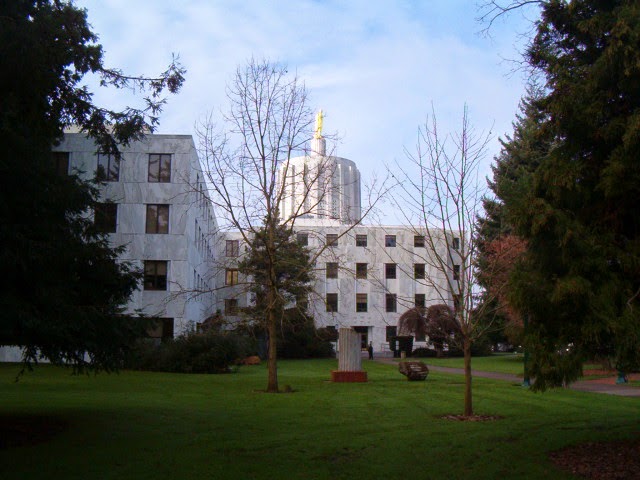
This walk starts at the beautiful Oregon State Capitol, constructed in 1938 after the previous capitol building burned to the ground in 1935. The part of the building in the foreground in this photo is actually one of two major 1977 additions, one on either side of the original building. This side is occupied by State Senators and their staffs. The entire building is scheduled to be vacated for over a year after the 2015 legislative session to accommodate a major seismic upgrade.

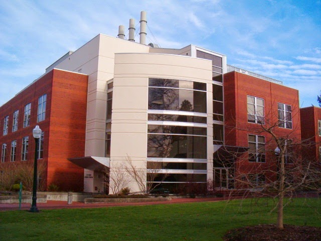
Start at the State Street side of the Capitol and turn left. Cross at the crosswalk near the intersection of State and Waverly to the Willamette University campus on the south side of State Street. The first building you will see is the newest major building on campus, Ford Hall. Named for major contributor Hallie Ford (she also has the university art museum named for her), the building was completed in 2009 and houses several university liberal arts programs.

Walk to the right of the Ford Center, and then continue to the right of the next building, Smullin Hall, which houses Willamette's information technology functions. Once past Smullin Hall turn left, and to your right will be the Pelton Theater, guarded by two lions out front. The theater was completed in 1923.


Once past the Pelton Theater and the parking lot next to it, turn right. Continue to a bridge over Mill Race Stream. Immediately beyond is the Martha Springer Botanical Garden, opened in 1998 as a tribute to a long-time biology professor. The small one-acre garden includes 12 micro-gardens. Mill Race is a diversion from Mill Creek to Mission Creek that provided water power to the Thomas Kay Woolen Mill located upstream from this location as well as several other long-ago departed industrial enterprises.

After crossing Mill Race and looking at the botanical garden veer right and and then go straight ahead. On your right is the Mark Hatfield Library and on the left is the Sparks Athletic Center. Once you get to the parking area turn left along the sidewalk and pass by the front of the Sparks Center. Continue to the right along the side of a soccer field until you get to Bellevue Street.

Turn left onto Bellevue, and after one block use the crosswalk to turn right on 12th Street. As you proceed south you will see, in the distance to the left, Salem's Amtrak Station, a beautiful Beaux-Arts style building constructed in 1918. Continue along this busy, undistinguished section of 12th Street, to Mission Street. You will pass by the popular Ram pub as well as a bridge over "Mission Creek" (about which more will be said later on the walk).

After you cross Mission Street the scenery takes a turn for the better. To the right is the Historic Deepwood Estate. This four-acre site is owned by the City of Salem as a public park, but the 1894 Queen Anne-style mansion is managed by Friends of Deepwood Estate, who provide organized tours of the home. The estate was given its name by Alice Powell, its final owner before the City acquired the property in 1971.


The estate is much more than just the grand mansion - the four acres of grounds also include beautiful gardens and a greenhouse that are open for free to the public. It is worth your time to wander through the gardens to admire the flora.


After you walk around and enjoy the Deepwood Estate grounds, go back onto 12th Street. After passing Lee Street, turn right onto Waller Street. After a block of ordinary apartment buildings you will come to this bridge, which crosses Pringle Creek. Use the bridge to cross the creek, then turn left onto the pathway.

You are now entering Bush's Pasture Park, a 90-acre greenspace. A stroll through the western half of the park is included on this walk - our route will go through the eastern part of the park. Continue past the trees into a large open grassy area, with trails that see a lot of use by joggers. Continue to the edge of the park at Leffelle Street, then turn right onto Leffelle (or stay on the pathway at the edge of the park which parallels Leffelle).
The neighborhood south of Bush's Pasture Park contains a number of old, attractive houses, such as this bungalow-style home, built in 1920, at the corner of Leffelle and Davidson.


Continue on Leffelle to its end at Summer Street, then turn left. Go one block and then turn right onto Cross Street. Go up a short hill on the next block, and at the top of the hill, after crossing Winter Street, is this stately Georgian-style home, built in 1934 for Custer Ross, a prominent local attorney. The American elm tree in front of the house is a lot older, dating from 1890, and is a Salem Heritage Tree

At Cottage Street turn right, and after one block you will reenter Bush's Pasture Park. Continue on the park trail that veers slightly to the left, on level terrain. When this path T's into another walking path turn right, and start going down a hill.


As you start on this path down the hill, to the right you will see this statue. It is entitled "Guidance of Youth," and depicts a pioneer family resolutely striding forward, presumably toward Oregon on the Oregon Trail. It was commissioned and placed on this spot in 1959 to commemorate the centennial of Oregon's admission as a state to the Union. Not mentioned on the plaque to the back of the statue is its interesting back story. It was commissioned and paid for with a $34,000 bequest from Carroll Moores, an evidently very thrifty janitor for the Oregon Supreme Court building. An earlier idea to use the money to purchase a painting of a nude by Auguste Renoir was the subject of significant local controversy, and was rejected.


After viewing the statue return to the trail and continue down the hill. You will be leaving the forested portion of the park and heading back into the grassy field portion of Bush's Pasture Park, but the last of the trees is this beautiful deciduous specimen.

At the bottom of the hill continue on the trail to the left. You will skirt the perimeter of the Willamette University baseball field and the University's McCulloch football stadium. The Willamette Bearcats participate in the NCAA at the Division III level. While the Bearcats don't have the consistent level of football excellence found at rival Northwest Conference foe Linfield College in McMinnville, the school plays at a generally high level, last winning the conference championship in 2008.

As you pass by the football stadium the trail branches. At the first branch go to the left, and almost immediately the trail will branch again - at this point, go to the right. You will be heading for the intersection of Mission Street and Winter Street. Cross Mission at the signal light, and proceed up Winter Street. You will soon be in going through the massive Salem Hospital campus. Salem Hospital is the only major public hospital in the city. Its recent plans to expand westward to Church Street has engendered some local controversy.

At the north end of the Salem Hospital campus, between the hospital and Bellevue Street, you will pass over this waterway (earlier you passed over it while on 12th Street near the Ram Restaurant). It is shown on some maps as Mission Creek, but it is actually the Shelton Ditch, a diversion canal from Mill Creek to Pringle Creek originally constructed in the mid-19th century. It is part of the complex set of creeks and ditches serving Salem with water that is for the most part diverted from the Santiam River to the south.

After Sheldon Ditch, you will cross busy Bellevue Street and continue north on Winter Street. You are now back at the edge of the Willamette University campus. On the left side of Winter, across from the main campus, is the Willamette University College of Law. The college is one of three law schools in Oregon, and has a healthy rivalry with the University of Oregon and Lewis and Clark law schools. The law school's main building, the Truman Wesley Collins Legal Center, was built in 1967,


To the right on Winter Street, before its intersection with State Street, is the Olin Science Center, constructed in 1995 and housing Willamette's biology and chemistry departments. 


Continue on Winter Street until it tees into State Street. On the block to the left are a series of interesting buildings. On the corner is the Civic Justice Center, home of the Oregon Law Commission, which inhabits Salem's 1912 Carnegie Library, with a classic beaux arts style used in many such libraries around the world. It served as Salem's public library until 1971, then was used by the YWCA until 2008, when it was refurbished by the law school and dedicated by none other than Supreme Court Justice Ruth Bader Ginsburg. Next on the block is the modern-style YWCA building, which has now been vacated by the YWCA, constructed in 1954. The architect was Pietro Belluschi. Next down is the art-deco style Pacific Telephone and Telegraph building, now occupied by CenturyLink, built in 1930. Finally, on the corner of State and Cottage, is the Hallie Ford Museum of Art, opened by Willamette University in 1998, with an excellent collection.

After taking a look at these buildings, turn right on State Street and return to the State Capitol. You will pass by the other 1977 addition to the original capitol, which primarily is occupied by members of the State House of Representatives and their staffs.

About Me

Blogs about biking and walking in the Pacific Northwest